Software
Houzz Logo Print
coffeebuild

Designing landscape drawing help

7 years ago
Hi all,


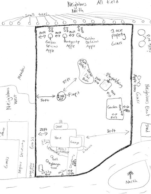
We are in a country home with 1 acre. We would like to add some privacy to our property while also adding some curb appeal. I have drawn a rough sketch of the property and what is currently here. The bold area is the property line. I have an idea of what I want but unsure on where to begin. My biggest problem is that I have such a blank slate to work with.


My main thing I want to accomplish right now is adding privacy to the 80 ft. SE section of our property. I would like to add privacy from the road while also adding curb appeal to the property. We would like to make it flow and look natural with the country area.


I tried to add some distances between areas of the yard to give an idea what I am working with. Field to the North of us, grass property neighbors to the East, half meadow/half grass property neighbors to the West and a road between us and the neighbors to the South.


Other things that I want to do in the future:

- Add privacy landscaping to rest of property starting with SW area of property and then looking at rest of property

- Build compost bin

- Build garden shed

- Build patio below deck area/behind garage area

- Plant 2-3 pear trees and 2-3 peach trees

- Plant raspberry patch


I need help with next steps. I am not sure where to begin to start this project. Any help would be appreciated!


Comments (5)

  • PRO
    7 years ago

    It sounds like you need to develop a master plan -- a "map" that shows where every architectural and landscape feature is -- for the whole property. It doesn't matter what actual work you'd like to implement first. If you have a master plan, you can pick whatever you want, and work on it in whatever order you'd like. It will still come out with everything being in the right place.

    The process of creating a master plan would start with creating an accurately drawn, to-scale base plan -- a "map" that shows the existing features that will remain -- the property line, house, drives, walks, walls, outbuildings, utility poles, tree trunks, garden beds, etc. -- and nothing extra. If something is subject to being relocated, don't include it in the base plan. Don't include measurements, hatching or shading, color, notes, small plants, tree canopies or anything temporary. For now, only add labels if they fit inside the object you're labeling (house, drive, garden, deck, etc.) The cleaner and easier to read the plan is, the better. Some of these things you'll add when the plan is turned into a master plan or landscape plan. It should look clean like this:

    (but without double lines.)

    While you can draw it with pencil and paper, using graph paper or plain paper and drawing tools, you would also be able to draw it in Microsoft Paint, using the line and rectangle tools. The advantage is no erasing, ability to undo, and that it's a computer file. Using those, it could be done with a mouse/trackpad and no need for touchscreen and stylus. It has a grid that can be turned on and off so you can get the measuring reasonably close. It uses a grid that is subdivided into 10. (It doesn't say, but it will come out to be 1" = 10'.)

    "I would like to add privacy from the road while also adding curb appeal to the property." I presume you are talking about different areas ...? As privacy and curb appeal are leaning in opposite directions. Curb appeal is hoping that outsiders will look at your property, and privacy is making sure they can't see anything.

    While you'll work on a whole master plan at one time, it's only practical to work on one general area of landscaping in one thread, or the subject could become confusing and hard to follow. You could use this thread for making the base map drawing and things related to that. And you could start a new thread for the front yard and another one later for the backyard (or whatever order you want to do it in.)

    When you to want to get help for creating a vision/concept for a given area, you'll want to include pictures of what's there now so people can understand the property you're working with. Avoid taking various disconnected pictures from different camera viewpoints. Instead, choose the scene that you want to work with as a whole complete scene. Line the camera up with the center of the scene. And then take a series of connected (slightly overlapping) pictures that pan from one end of the scene to the other while the camera remains at the single location for all pictures of the scene.

  • 7 years ago

    Thanks for the help. I will work on making a master plan picture in paint like you stated.

  • PRO
    7 years ago

    Even though it is simple, there are a few quirky puzzles that are also included free of charge. :-) If you run into anything confusing with it, just ask. You can create a shape (such as a rectangle for the house) in upper left corner in order to measure it against the scale, then you have an opportunity to drag the shape, as a whole, without modifications, to any other location before "depositing," it. Its best features are the ability to select and relocate already-drawn features, massive, smudge-free erasing, and undo.

  • 7 years ago

    However you construct your base map, make sure it is to scale. Without things drawn to a proper scale, you are unable to get a good sense of placement or how to correctly space the plants and any other elements to be included.

    It is also hard to use a workable scale for a full acre sized property. If small enough to include the entire property on a single drawing, it is too small for accurate plant placement. Typically you will want to narrow down the drawing to focus on specific areas drawn at a larger scale to be able to site and locate (and label) all plantings to be included clearly enough.

  • PRO
    7 years ago

    100% true about being accurate to scale and adjusting the scale for workability. If drawing on paper, a workable scale for the whole property might require a 20" x 30" sheet, or breaking up the drawing into smaller sections. A great advantage to drawing such a large property in MS Paint is that the sheet size is virtually unlimited. Since the scale is 1" = 10', the whole drawing is at a scale workable for plant placement, regardless of the property size. Any portion of it can be enlarged by zooming in, and the whole or any portion of it, can be printed out at various sizes. The shift key, in conjunction with some drawing tools, allows for making perfect circles, squares, horizontal, vertical or 45* diagonal lines. The program is a pretty versatile tool, yet simple to use ... or I couldn't use it!!! (While it works great for a base plan, unfortunately, it is not CAD, which would be much more flexible for designing.)