

Questions on the accuracy of surveyor pins and surveys.
Browsing the forums here this seems the most appropriate place for this question. If you know of other forums on GardenWeb or elsewhere that might be better suited for this question, I'd love to know.
We are having a housing boom in our little Detroit suburb. A group of us are believe our building department is not doing their job to enforce the zoning and builders are regularly being allowed to build inside setbacks.
To substantiate this claim, we found the surveyor pins on the front corner of two properties and used that as the first of our reference points. We were told two things by some members of our Zoning Board of Appeals regarding this:
(1) You can never trust a survey pin. They are highly inaccurate.
(2) If a builder gets a survey that he doesn't like, he'll just call a second surveyor in because no two surveys are ever the same.
I wanted to get the opinion of folks that are either surveyors or have worked closely with them. Is there any truth to these claims?
I know survey pins can be moved, or what a person thinks is a survey pin may not actually be one. However, here are some additional details.
A large number of the properties in the city have chain link fences on the rear and side lot lines. When I had my own survey done we found the rear corner posts were exactly at the corner. We assumed this is also the case for the fences at the two sample properties (though not necessarily a correct assumption). When comparing the survey pins, the rear posts, and the existing fence, they seem to be built exactly on the property line.
The lots are 40 feet wide here. At one property we found a neighbor's pin exactly 40 feet away. It seems unlikely both would have been moved by the exact same amount. We are going to look for a second pin at the other property.
Two other properties had stake surveys done to mark the property boundaries. Measurements from the stakes demonstrated setback violations.
Because there are many properties that we believe are in violation it would be quite expensive for us to have all of them surveyed, although if it comes to it we might start raising funds.
The city does not require a survey be performed before building starts.
The neighborhoods were originally built in the 30's through the 50's. The surveyor pins we found are metal iron pipe and not rebar if that helps to give a clue to their age.
Since none of us are professional builders or planners, and I'm the only one of our group that has had a house built, we'd welcome any help to make sure we fully understand all the nuances of finding property boundaries. Thanks!
-Dennis
Comments (16)
 10 years ago
I'm not answering your question, but I'm curious, who is we, and why do you care enough to go vigilante on new development in a city that sorely needs it?
 10 years ago
I too am not a professional but I think your instincts are correct not to trust the information from the Zoning Board of Appeals. Would they be willing to put in writing the two statements referenced above? They seem almost libelous and certainly an insult to both surveyors and builders.
I hope a professional is able to provide you some insights.
Good luck!
Related Professionals
Anderson Architects & Building Designers · Clarksburg Architects & Building Designers · Gloucester Architects & Building Designers · Portland Architects & Building Designers · Fort Collins Architects & Building Designers · Butte Architects & Building Designers · Waycross Design-Build Firms · Augusta Design-Build Firms · Bridgeport Design-Build Firms · Queens Design-Build Firms · Sebring Home Builders · West Palm Beach Home Builders · Del Rio Home Builders · Boise Home Builders · Scottsbluff Home Builders- 10 years ago
(1) You can never trust a survey pin. They are highly inaccurate.
(2) If a builder gets a survey that he doesn't like, he'll just call a second surveyor in because no two surveys are ever the same.
As a former builder, I have never heard of this. In my state, any surveyor who messes up (on purpose or accidentally), is in great risk of losing their license, and being sued. They are also liable (and I've seen it), for other actions that were taken on behalf of their work, like buildings in the wrong place. I would question both the credentials and the ethics of this board.
 10 years ago
With GIS, robots and all sorts of tools - a good surveyor can be VERY accurate. They have to be on things like overpasses, bridges, really tall buildings, etc - that crap is kinda important.
Where they might vary a little is pounding in a stake during a lot survey.
My brother is a surveyor and he's been out marking a ton of stuff for us - he has nail heads with indentations in them to mark the exact point. He just did this for our screened porch footings. So while you might see variation - I would expect it would be more of an inch or 2 depending on the stake pounding variation and a lazy surveyor who didn't check the top of the stake again after installation. But it really should not be far off.
- 10 years agolast modified: 10 years ago
>Questions on the accuracy of surveyor pins and surveys.
Modern equipment does measurements pretty precise 1/4" - 1/8", however the usual surveys requirements - 1". Sometimes it is not even possible as legal description may contain references to a tree ( I am not kidding ), , or 6"x6" monument.
>A group of us are believe our building department is not doing their job to enforce the zoning and builders are regularly being allowed to build inside setbacks.
No kidding. They really represent the city and not You. They are concerned about over all look and they do grant variances if necessary. They not going to make builder move a house because of 1'. They could fine builder and take even more serious actions when builder consistently violated ordinances.
>(1) You can never trust a survey pin. They are highly inaccurate.
>(2) If a builder gets a survey that he doesn't like, he'll just call a second surveyor in because no two surveys are ever the same.
No to both. They are reasonably accurate.The surveyor is licensed and liable. I do not think builder would do this. It is a waste of money you can ran into some major legal issues. The less ethical builder could just move a stakes and play ignorant [blame it on kids].
> It seems unlikely both would have been moved by the exact same amount.
If one surveying company placed a pin and noted on the plat map, the second surveyor will use it as a reference point. They both may be wrong, but this would be consistently wrong and have the strait setback line vs jagged one. One of the houses I built, had 30' subdivision setback (b/l) was set from old road. Within a month of receiving the permit the road was repaved width increased by 1.5'. House was built on the building line so instead of 30' it became 28'. Adjacent houses used the same reference point. Also how are you measuring? based on terrain contour? That would not be accurate.
Dear Don Quixote - you may be fighting windmills. Mistakes are made as long as they are not egregious: don't place two houses 5' from each other [firecode], don't prevent emergency vehicles from getting into neighbor house, and a builder does not show general disdain for ordinances - building department can forgive certain errors.
- 10 years agolast modified: 10 years ago
"The city does not require a survey be performed before building starts."
This is the problem. To enforce setbacks it is necessary to require a survey in order to get a permit for new construction or renovation and to require the surveyor to verify the location of the work before a Certificate of Occupancy can be issued. I've never built in a town that did not enforce these simple requirements.
If a survey is not required to build how could the builder even know he was placing the foundation correctly? He should work from the surveyor's stakes not pins.
You are focusing on the wrong issue. Surveyors are not causing a problem, your town is.
You should be able to look at a plot plan or survey at the building department for any building in your town built in the last 100 years.
I have found inaccuracies in surveys but very rarely and of little consequence.
What is your plan, to have the houses that are in violation altered to meet the setbacks?
- 10 years agolast modified: 10 years ago
The Quixotic comment is pretty accurate - To what end are you and your friends pursuing this? Zoning ordinances are not sacred and zoning boards can ignore them at will. They are essentially only planning tools, and it is unlikely that zoning ordinances established in the 1930's are still effective at their intended purpose (which is to increase the economic health of the community).
Your biggest problem is, "because there are many properties that we believe are in violation it would be quite expensive for us to have all of them surveyed..." So long as they are equitably enforcing the zoning laws (or in this case equitably not enforcing them), you really can't do anything about it. So save your money on the surveys, because when you find out they are wrong nothing will happen. Political pressure, and not legal pressure, is your only real option. Unless I miss my guess about the economic development of Detroit suburbs, I doubt you are going to win the battle of public opinion. They will simply respond with, "Our relaxation of zoning standards has brought in significant economic growth, increased our tax base and established our community as a flourishing Detroit suburb."
You might even help them by pursuing it!
hennen
Original Author10 years agoTwo answer some questions and offer some clarification:
The two points I listed were not made during the ZBA (zoning board of appeals) meeting but by individuals afterwards, so it is only the opinion of some, not necessarily all, members.
We'll definitely be asking city council to require a survey before any work begins.
Most of the city is nearly completely flat. The areas of concern we are measuring are definitely flat.
Our focus is definitely not surveyors. I'm trying to learn about the surveying process so I know if the arguments actually have merit.
Our focus is definitely on the city. Our secondary focus is builders that, in the best case, are being sloppy knowing there has been lax enforcement.
The properties we are focusing on are new builds. We can't change the past. We aren't going to ask that homes be torn down. We are trying to prevent problems down the road.
Three specific instances to help illustrate the concern.
There is one property encroaching the side setback by, we believe, by 7 inches. We met with the city inspector at the property and he measured it with us. He said no, this is fine, the neighbor's driveway actually encroaches the new property by 6 inches. This is when we started looking for the survey pin. We are pretty sure a survey was not done, but there is a site plan we have, and even the site plan shows the property boundary 2 inches before the driveway's edge, not 6 inches into it. Had he been using the site plans his own department provided us he would have known his error.
This same property has a projection for a gas fireplace that, by code and according to the site plan, may only be 10". It is currently 18". That one I'd argue should come out since the house is still under construction and it is still for sale - we are only impacting the improper build that I don't think is that hard to remedy.
The third thing is an issue that came before the ZBA recently. 20 years ago a car part was built and inspected by the same inspector we have today. Some of the facts are murky as they just came out and need some more research, but it appears this passed inspections even though a variance should have been required. The person who owns the home today came before the ZBA for a variance that was, I think rightly, denied. However, his issues may stem back to lax code enforcement from long before he lived here. These are the issues we are trying to prevent - not to prevent building but to protect future homeowners and neighbors.
There are numerous other code violations at building sites being allowed in the city, but I'm only discussing the zoning issues here. The zoning issues are just part of a larger pattern of neglect from the city.
Regarding public opinion. We actually have strong public support and the city is definitely starting to make positive changes. We're trying to continue to move that progress forward.
For my background, I moved here 5 years ago into a house I had built. I am definitely not against new builds. I'm for responsible building practices and equitable enforcement of codes by the city.
 10 years agolast modified: 10 years ago
I have found that survey pins do get moved. By vandals, neighbourhood busybodies and cranks.
The last removed pin I encountered was taken from the adjacent property owner's driveway--he was encroaching on the property I was building on and thought that removing the pin would hide that. I didn't insist on him removing his encroachment. With a house being built, then vacant for a year before being sold, the risk wasn't worth it, I figured.
The instances raised by the OP, if accurate, would be "minor variances" that would likely be allowed in the jurisdictions I have built in.
We'll definitely be asking city council to require a survey before any work begins.
I'm surprised that isn't required already. Here, and I would have thought in most jurisdictions, surveys are required with the submission of plans and after the foundation is finished.
- 10 years agolast modified: 10 years ago
Again - I believe you are tilting at windmills.
You really can't force a zoning commission to follow the rules. They can keep giving you B.S. excuses and you probably can't sue them. I doubt you even have standing to sue and even if you did, you would probably lose. So long as they consistently don't care you can't really do anything about it.
In fact, you can open a messy can of worms with this. If the zoning board has a long history of not following the rules and you pressure them to start following them. Then the new property owners can sue the zoning board to have all previous properties with a defect brought up to code. The only real hard and fast rule is that zoning boards can't selectively enforce the rules.
There is no need for a zoning board to enforce a driveway encroachment onto another property as that would be the homeowner's responsibility. A zoning board will enforce easements and setbacks from public and publicly reserved property, but they will rarely enforce encroachment onto private property. If the neighbor who is upset about losing 6" wants to sue their neighbor, they can.
- 10 years agolast modified: 10 years ago
I don't know how to be polite with this next part so I am not going to try, but I want it to be constructive.
There is one property encroaching the side setback by, we believe, by 7 inches. We met with the city inspector at the property and he measured it with us. He said no, this is fine - This was the exact point that I became pretty happy to not live in your community.
You really have so much free time that you went to someone else's property and did all the work to find the property line and then measure because it looked 7 inches over! Then were so upset about it that you called the inspector out... I would consider this a tragic waste of time and tax dollars.
 10 years ago
Surveys are highly accurate and are considered a legal document in court ( in my state ).
- 9 years ago
The question I have is about the accuracy of old surveys, and where the legality is. The most extreme example of this is the old description of a county boundary. This is describing a boundary creating a new county out of part of Clinton County: "Be it enacted by the People of the State of New York represented in Senate and Assembly, That all of that part of the County of Clinton lying south of a line beginning at the south west corner of the town of Peru, and running from thence easterly along the south line of said town until it intersects the great river Ausable, from thence along the north bank of the south branch of said river until it strikes Lake Champlain...". (The text here continues for quite awhile, but my point is made here). The point is that now, that county line runs at an azimuth of approximately 83 degrees (due east is 90 degrees). This Act was passed in 1799. I thought that the surveyors then didn't know about magnetic declination, and that these descriptions were based on magnetic north, not geographic north, as modern surveys are made, but the error is about 7 degrees, while the magnetic declination correction was about 11 degrees then (in 1983 it was 14 degrees 3 minutes). So, I have two general questions:
1. in such cases as this, were subsequent acts passed to correct the description? I assume that the original description is recognized as being in error.
2. Or, are the monuments placed in 1799 now the defining description and a new survey would (and probably was) made to give the precise description.
I attach below the map of the new county:
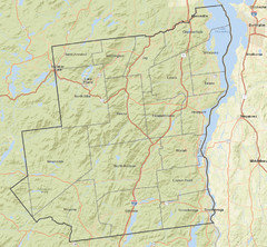
I apologize for hijacking this thread, but I could not figure out how to create a new one for this subject.
Now, I copy here a portion of the deed for some property I purchased in 2013:
"ALL THAT CERTAIN PARCEL OF LAND being located in the Town of Elizabethtown, County of Essex, State of New York, being part of the property described....
BEGINNING at a found 3/4" iron rod in concrete 0.1' below grade located at the northwest corner of the herein described parcel and the southwest corner of (someone else's property), said iron rod being located on the easterly assumed road bounds of .... road, as shown on Essex County File Map No. ---, said iron rod being also located S20*59'01" as referenced to New York State Grid North by 1983 Datum by GPS observations a distance of 250.34 feet along said rod bound from a capped iron road locate at the southwest corner of (someone else's property) and running:
1....." Following here is the description of the entire plot, ending with "7. N20*01'25" E 303.43 feet to the point of the beginning containing 15.0 acres, more or less, with the above described bounds."
The two points I make here is the reference to "found rods", and the quoted accuracy of the measurements. Can a surveyor make measurements this accurate? The distances are quoted to 1/100 of a foot, which is about an eighth of an inch, and do typical surveying instruments even register one second of arc?
Comments from professional surveyors, please.
- 9 years ago
mtvhike, there is a lot to respond to in your questions. I am a professional surveyor (33 years), so I can answer your questions.
Before I begin, please understand that I am a surveyor from Michigan. Although I have decades of experience in Michigan, but none in New York. Surveys in Michigan are based on the Public Land Survey System that did not exist when surveys were originally performed in New York. While I believe that my responses are applicable, your best source of information would be a New York licensed surveyor.
Let me start with the easy part. Regarding accuracy, yes we can measure that accurately. Our instruments can easily measure to the 100th of a foot and the nearest second of arc. That is often an indicator of a property having been surveyed when the description contains that level of accuracy. It should also be understood that there are many factors involved in a single measurement, all of which affect the ability to measure distances and angles to this level of accuracy. The instrument is only one factor.
Now, dealing with the accuracy of old surveys. Most often, accuracy is a function of the surveyor's skill. The instruments were less accurate than today's instruments, but still capable of conducting reasonably accurate work. But, accuracy in measurements is not the key test of old descriptions. "Intent" is the objective that we are trying to understand. County descriptions in my state may or may not be surveyed. The intent of these descriptions is to define general areas to be included within a county. As long as the description defines the location of a county line such that properties on either side can determine the county in which their property resides, then the description's intent was clear and the accuracy is sufficient.
The "found 3/4" iron rod" is a "call" to an artificial monument. In the hierarchy of evidence evaluation, a call to an artificial monument supersedes bearings and distances. If you can find the referenced rod or other such artificial monuments specifically called for in the description, then those artificial monuments will define the boundary. They are considered as the best evidence of the intent of the original survey.
In summary, surveyors can easily measure with a high level of accuracy. We use these accurate measurements as more of an indicator of intent as opposed to an absolute delineation of a boundary. If other information conclusively defines that boundary, such as calls to adjoiners (neighbors) or calls to monuments, then we are obligated to honor the intent of the original description, which may differ from the measurements in the description. A surveyor's unique skill is not the ability to measure a distance accurately, but to understand the accuracy required, the methods to achieve the required accuracy and the appropriate application of the accurate measurements.
- 9 years ago
Thank you, Craig, you have answered several of my questions. I followed the metes-and-bounds description of my property line, trying to find the surveyor's monuments (if that's what they are called; the old ones were 1" diameter brass discs on rocks, the newer ones were aluminum "spikes" with 2" diameter heads with the name of the surveyor embossed on them. I successfully found most of them (this is very hilly country in deep woods and I only found them because the surveyor had put a ribbon on the branch of a nearby tree), but a couple I cannot find. The most difficult one has the following description:
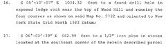
This is important to me because it defines the boundary of my property in a location where I would like to build a cabin. I had no difficulty finding the previous monument (#15), but cannot find the following one (#18) because it is so heavily wooded and also in the vicinity of cliffs! I have a copy of map 2732 . What is meant by "four courses"? Intermediate points or markers along the 1034.32 length of this?






Craig Amey