
Search results for "Volunteer" in Home Design Ideas

 Envision Web
Stuart Wade, Envision Virtual Tours, Inc.
Envision Virtual Tours and High Resolution Photography is your best choice to find just what you are looking for in the Lake Burton Area . Knowing the areas and resources of Lake Burton is our specialty
Lake Burton is a 2,775 acre man-made lake with 62 miles of shoreline located in the northeastern corner of Georgia in Rabun County. It is the first lake in a five-lake series called the Tallulah River Watershed that follows the original course of the Tallulah River. The series of lakes starts with Lake Burton as the northernmost lake followed by Lake Seed, Lake Rabun, Lake Tallulah Falls and the eastern arm of Lake Tugalo (the western arm is formed by the Chattooga River. The lakes are owned and operated by the Georgia Power Company to generate hydroelectric energy for Georgia's largest city, Atlanta. At one time these lakes were the largest producers of electricity in the state of Georgia. Now, they only provide peak power supply.
The lake was built in a deep valley located along a 10 mile section of the Tallulah River. The Lake Burton Dam was closed on December 22, 1919 and the lake started to fill. The dam is a gravity concrete dam, with a height of 128 feet and a span of 1,100 feet. The spillway is equipped with eight gates 22 feet wide by 6.6 feet high. The total capacity at an elevation of 1,866.6 feet is 108,000 acre-ft, of which 106,000 acre-ft is usable storage. The generating capacity of the dam is 6,120 kilowatts (two units).Lake Burton is the highest Georgia Power lake in Georgia.
Lake Burton gets its named from the town of Burton, which was the second largest town in Rabun County with a population of approximately 200 but now lies below the lake's surface. The town (and the lake) was named after local prominent citizen Jeremiah Burton and was situated along the road from Clayton, Georgia to the Nacoochee Valley. Andrew Jackson Ritchie served as the postmaster for the area for several years. Gold was first discovered in Rabun County where Dicks Creek and the Tallulah River come together and was the reason for the town's founding in the early 1800s.
The Lake Burton Fish Hatchery and Moccasin Creek State Park are located on the western side of the lake. Lake Burton is home to several species of fish, including Spotted Bass, Largemouth Bass, White Bass, Black Crappie, Bluegill, Redear Sunfish, White Catfish, Walleye, Brown Trout, Rainbow Trout, and Yellow Perch.
The residents of Lake Burton are a mix of permanent residents and seasonal vacationers who together make-up the Lake Burton Civic Association, a local organization who goal is to maintain the lake through volunteer clean-ups and other such events. Let a Lake Burton resident and expert show you the way
The Lake Burton Civic Association is an active homeowners association for residents of the Lake Burton area and sponsors many events throughout the year such as:
burton, custom, envision, georgia, lake, mountain, nc, north, photography, web, western, Lake Burton, Lake Rabun, Seed Lake,Virtual Tours.
 Envision Web
Stuart Wade, Envision Virtual Tours, Inc.
Envision Virtual Tours and High Resolution Photography is your best choice to find just what you are looking for in the Lake Burton Area . Knowing the areas and resources of Lake Burton is our specialty
Lake Burton is a 2,775 acre man-made lake with 62 miles of shoreline located in the northeastern corner of Georgia in Rabun County. It is the first lake in a five-lake series called the Tallulah River Watershed that follows the original course of the Tallulah River. The series of lakes starts with Lake Burton as the northernmost lake followed by Lake Seed, Lake Rabun, Lake Tallulah Falls and the eastern arm of Lake Tugalo (the western arm is formed by the Chattooga River. The lakes are owned and operated by the Georgia Power Company to generate hydroelectric energy for Georgia's largest city, Atlanta. At one time these lakes were the largest producers of electricity in the state of Georgia. Now, they only provide peak power supply.
The lake was built in a deep valley located along a 10 mile section of the Tallulah River. The Lake Burton Dam was closed on December 22, 1919 and the lake started to fill. The dam is a gravity concrete dam, with a height of 128 feet and a span of 1,100 feet. The spillway is equipped with eight gates 22 feet wide by 6.6 feet high. The total capacity at an elevation of 1,866.6 feet is 108,000 acre-ft, of which 106,000 acre-ft is usable storage. The generating capacity of the dam is 6,120 kilowatts (two units).Lake Burton is the highest Georgia Power lake in Georgia.
Lake Burton gets its named from the town of Burton, which was the second largest town in Rabun County with a population of approximately 200 but now lies below the lake's surface. The town (and the lake) was named after local prominent citizen Jeremiah Burton and was situated along the road from Clayton, Georgia to the Nacoochee Valley. Andrew Jackson Ritchie served as the postmaster for the area for several years. Gold was first discovered in Rabun County where Dicks Creek and the Tallulah River come together and was the reason for the town's founding in the early 1800s.
The Lake Burton Fish Hatchery and Moccasin Creek State Park are located on the western side of the lake. Lake Burton is home to several species of fish, including Spotted Bass, Largemouth Bass, White Bass, Black Crappie, Bluegill, Redear Sunfish, White Catfish, Walleye, Brown Trout, Rainbow Trout, and Yellow Perch.
The residents of Lake Burton are a mix of permanent residents and seasonal vacationers who together make-up the Lake Burton Civic Association, a local organization who goal is to maintain the lake through volunteer clean-ups and other such events. Let a Lake Burton resident and expert show you the way
The Lake Burton Civic Association is an active homeowners association for residents of the Lake Burton area and sponsors many events throughout the year such as:
burton, custom, envision, georgia, lake, mountain, nc, north, photography, web, western, Lake Burton, Lake Rabun, Seed Lake,Virtual Tours.
Find the right local pro for your project

 Peabody Landscape Group
Pictured here is a view from the back of the pool looking at the back of this Nantucket Styled home. Tucked seamlessly within the design, the pool offers an oasis of refreshment, reflecting the clear blue hues of the Atlantic.
 NSPJ Architects
 / Cathy Kudelko
Home design - transitional home design idea in Kansas City
Home design - transitional home design idea in Kansas City
 Envision Web
Stuart Wade, Envision Virtual Tours
Envision Virtual Tours and High Resolution Photography is your best choice to find just what you are looking for in the Lake Burton Area . Knowing the areas and resources of Lake Burton is our specialty
Lake Burton is a 2,775 acre man-made lake with 62 miles of shoreline located in the northeastern corner of Georgia in Rabun County. It is the first lake in a five-lake series called the Tallulah River Watershed that follows the original course of the Tallulah River. The series of lakes starts with Lake Burton as the northernmost lake followed by Lake Seed, Lake Rabun, Lake Tallulah Falls and the eastern arm of Lake Tugalo (the western arm is formed by the Chattooga River. The lakes are owned and operated by the Georgia Power Company to generate hydroelectric energy for Georgia's largest city, Atlanta. At one time these lakes were the largest producers of electricity in the state of Georgia. Now, they only provide peak power supply.
The lake was built in a deep valley located along a 10 mile section of the Tallulah River. The Lake Burton Dam was closed on December 22, 1919 and the lake started to fill. The dam is a gravity concrete dam, with a height of 128 feet and a span of 1,100 feet. The spillway is equipped with eight gates 22 feet wide by 6.6 feet high. The total capacity at an elevation of 1,866.6 feet is 108,000 acre-ft, of which 106,000 acre-ft is usable storage. The generating capacity of the dam is 6,120 kilowatts (two units).Lake Burton is the highest Georgia Power lake in Georgia.
Lake Burton gets its named from the town of Burton, which was the second largest town in Rabun County with a population of approximately 200 but now lies below the lake's surface. The town (and the lake) was named after local prominent citizen Jeremiah Burton and was situated along the road from Clayton, Georgia to the Nacoochee Valley. Andrew Jackson Ritchie served as the postmaster for the area for several years. Gold was first discovered in Rabun County where Dicks Creek and the Tallulah River come together and was the reason for the town's founding in the early 1800s.
The Lake Burton Fish Hatchery and Moccasin Creek State Park are located on the western side of the lake. Lake Burton is home to several species of fish, including Spotted Bass, Largemouth Bass, White Bass, Black Crappie, Bluegill, Redear Sunfish, White Catfish, Walleye, Brown Trout, Rainbow Trout, and Yellow Perch.
The residents of Lake Burton are a mix of permanent residents and seasonal vacationers who together make-up the Lake Burton Civic Association, a local organization who goal is to maintain the lake through volunteer clean-ups and other such events. Let a Lake Burton resident and expert show you the way
The Lake Burton Civic Association is an active homeowners association for residents of the Lake Burton area and sponsors many events throughout the year such as:
burton, custom, envision, georgia, lake, mountain, nc, north, photography, web, western, Lake Burton, Lake Rabun, Seed Lake,Virtual Tours.
 Envision Web
Stuart Wade, Envision Virtual Tours
Envision Virtual Tours and High Resolution Photography is your best choice to find just what you are looking for in the Lake Burton Area . Knowing the areas and resources of Lake Burton is our specialty
Lake Burton is a 2,775 acre man-made lake with 62 miles of shoreline located in the northeastern corner of Georgia in Rabun County. It is the first lake in a five-lake series called the Tallulah River Watershed that follows the original course of the Tallulah River. The series of lakes starts with Lake Burton as the northernmost lake followed by Lake Seed, Lake Rabun, Lake Tallulah Falls and the eastern arm of Lake Tugalo (the western arm is formed by the Chattooga River. The lakes are owned and operated by the Georgia Power Company to generate hydroelectric energy for Georgia's largest city, Atlanta. At one time these lakes were the largest producers of electricity in the state of Georgia. Now, they only provide peak power supply.
The lake was built in a deep valley located along a 10 mile section of the Tallulah River. The Lake Burton Dam was closed on December 22, 1919 and the lake started to fill. The dam is a gravity concrete dam, with a height of 128 feet and a span of 1,100 feet. The spillway is equipped with eight gates 22 feet wide by 6.6 feet high. The total capacity at an elevation of 1,866.6 feet is 108,000 acre-ft, of which 106,000 acre-ft is usable storage. The generating capacity of the dam is 6,120 kilowatts (two units).Lake Burton is the highest Georgia Power lake in Georgia.
Lake Burton gets its named from the town of Burton, which was the second largest town in Rabun County with a population of approximately 200 but now lies below the lake's surface. The town (and the lake) was named after local prominent citizen Jeremiah Burton and was situated along the road from Clayton, Georgia to the Nacoochee Valley. Andrew Jackson Ritchie served as the postmaster for the area for several years. Gold was first discovered in Rabun County where Dicks Creek and the Tallulah River come together and was the reason for the town's founding in the early 1800s.
The Lake Burton Fish Hatchery and Moccasin Creek State Park are located on the western side of the lake. Lake Burton is home to several species of fish, including Spotted Bass, Largemouth Bass, White Bass, Black Crappie, Bluegill, Redear Sunfish, White Catfish, Walleye, Brown Trout, Rainbow Trout, and Yellow Perch.
The residents of Lake Burton are a mix of permanent residents and seasonal vacationers who together make-up the Lake Burton Civic Association, a local organization who goal is to maintain the lake through volunteer clean-ups and other such events. Let a Lake Burton resident and expert show you the way
The Lake Burton Civic Association is an active homeowners association for residents of the Lake Burton area and sponsors many events throughout the year such as:
burton, custom, envision, georgia, lake, mountain, nc, north, photography, web, western, Lake Burton, Lake Rabun, Seed Lake,Virtual Tours.

 User
Detail of Iridescent Venetian plaster finish on all walls in Living Room by Christianson Lee Studios
Example of a transitional home design design in New York
Example of a transitional home design design in New York
 Envision Web
Stuart Wade, Envision Virtual Tours
Envision Virtual Tours and High Resolution Photography is your best choice to find just what you are looking for in the Lake Burton Area . Knowing the areas and resources of Lake Burton is our specialty
Lake Burton is a 2,775 acre man-made lake with 62 miles of shoreline located in the northeastern corner of Georgia in Rabun County. It is the first lake in a five-lake series called the Tallulah River Watershed that follows the original course of the Tallulah River. The series of lakes starts with Lake Burton as the northernmost lake followed by Lake Seed, Lake Rabun, Lake Tallulah Falls and the eastern arm of Lake Tugalo (the western arm is formed by the Chattooga River. The lakes are owned and operated by the Georgia Power Company to generate hydroelectric energy for Georgia's largest city, Atlanta. At one time these lakes were the largest producers of electricity in the state of Georgia. Now, they only provide peak power supply.
The lake was built in a deep valley located along a 10 mile section of the Tallulah River. The Lake Burton Dam was closed on December 22, 1919 and the lake started to fill. The dam is a gravity concrete dam, with a height of 128 feet and a span of 1,100 feet. The spillway is equipped with eight gates 22 feet wide by 6.6 feet high. The total capacity at an elevation of 1,866.6 feet is 108,000 acre-ft, of which 106,000 acre-ft is usable storage. The generating capacity of the dam is 6,120 kilowatts (two units).Lake Burton is the highest Georgia Power lake in Georgia.
Lake Burton gets its named from the town of Burton, which was the second largest town in Rabun County with a population of approximately 200 but now lies below the lake's surface. The town (and the lake) was named after local prominent citizen Jeremiah Burton and was situated along the road from Clayton, Georgia to the Nacoochee Valley. Andrew Jackson Ritchie served as the postmaster for the area for several years. Gold was first discovered in Rabun County where Dicks Creek and the Tallulah River come together and was the reason for the town's founding in the early 1800s.
The Lake Burton Fish Hatchery and Moccasin Creek State Park are located on the western side of the lake. Lake Burton is home to several species of fish, including Spotted Bass, Largemouth Bass, White Bass, Black Crappie, Bluegill, Redear Sunfish, White Catfish, Walleye, Brown Trout, Rainbow Trout, and Yellow Perch.
The residents of Lake Burton are a mix of permanent residents and seasonal vacationers who together make-up the Lake Burton Civic Association, a local organization who goal is to maintain the lake through volunteer clean-ups and other such events. Let a Lake Burton resident and expert show you the way
The Lake Burton Civic Association is an active homeowners association for residents of the Lake Burton area and sponsors many events throughout the year such as:
burton, custom, envision, georgia, lake, mountain, nc, north, photography, web, western, Lake Burton, Lake Rabun, Seed Lake,Virtual Tours.
 Envision Web
Envision Virtual Tours, Stuart Wade
Envision Virtual Tours and High Resolution Photography is your best choice to find just what you are looking for in the Blairsville Area . Knowing the areas and resources of Lake Nottely is our specialty. Whether you're looking for fishing on Lake Nottely, information and history of Blairsville, Ga. Learn all about Blairsville, Ga. here!
Blairsville, the county seat of Union County, was incorporated on December 26,1835 and remains the sole incorporated community in the county. At the heart of Downtown Blairsville is the Historic Union County Courthouse, constructed in 1899, and now home to everything from the Union County Historical Society and Friday Night Concerts to a military museum and dollhouse collection. Nearby is the Blairsville City Hall (formerly the "old" jail built in 1934). Both historical buildings are on the National Register of Historic Places.
Blairsville's Town Square is frequently the venue for annual events such as the Downtown Spring Arts & Crafts Festival, the Memorial Day Parade, the Green Bean Festival, the Bluegrass Festival, the Sorghum Parade, Hometown Halloween on the Square, and the Christmas Parade. Everyone is invited to these family orientated celebrations!
Just south of the Square, the Historical Society develops and maintains the Mountain Life Museum. It is home to the 1906 Grapel Mock House, the 1861 Payne Cabin, and annual events such as the Mountain Market and Heritage Festival. Look for live animals, heritage demonstrations, and hands-on activities such as panning for gold.
There are many exciting destinations in and around Blairsville. Meeks Park, Butternut Creek Golf Course, Lake Nottely, Helton Creek Falls, and the Appalachian Trail are a few of the most well-known attractions.
Blairsville is the place to be for outdoor fun. Nearly two-thirds of Union County is in the Chattahoochee National Forest. It includes Georgia's highest point, Brasstown Bald (with a visitors' center at the summit), Vogel State Park (the oldest and most popular state park in Georgia), and the Richard Russell Scenic Byway.
In 2011, Blairsville was designated as an official Appalachian Trail Community. This designation recognizes Blairsville for its part in promoting awareness of the Appalachian Trail as an important national and local resource.
In 2007 Blairsville was recognized as a Georgia Better Hometown, largely due to the community volunteer efforts of the Downtown Development Authority of Blairsville. Blairsville has many dedicated individuals and organizations that work together to make the city a great place to live (and to visit). Welcome to Blairsville, Georgia!
 Debby Evans Garden Design
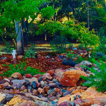
Photos by Debby Evans. This property slopes from the street to a seasonal creek in the back yard. Navigating the various spaces was troublesome so we created various, natural - as well as concrete steps, crushed granite pathways, stone steps, and flagstone - travel options throughout the landscape. Updated irrigation, efficient drainage, as well as dry creek beds to catch rain water that previously had simply gone directly at the residence were added. Many diseased, dangerous (hanging over the residence) oaks were assessed by several arborists. Sadly, more than 100 (mostly scrub oaks) required removal. This changed the natural lighting to the garden, how the sun impacted the residence, and offered opportunities to plant drought tolerant trees and shrubs of both visual interest, and fitting the space. Client had quite a few Japanese Maples that had originally been volunteers from a very large maple at another residence. All have been used and are doing beautifully. Olive trees and Little Ollie shrubs were used along with Carpet Roses, Lorapetalum, several varieties of Grevellia, Crape Myrtle Natchez and Red Rocket trees and shrubs, Maiden Hair grass, Blue Fescue, Redwoods, a specimen Limelight Hydrangea, Cistus, native Redbud, Vinca, Tree Hibiscus, Tree Roses, Birch, Dogwood, Penstemon, Pittosporum, Heavenly Bamboo, Miniature Roses, Succulents, Euphorbia, Bloodgood Maple, Redtwig Maple, Podocarpus and Oleander (screening), various groundcovers, evergreen shrubs and more were selected for their ease of care, color, seasonal color, and dynamic - but not busy - plant palette. The dated deck was redone with a relocation of the stairs to go directly to the pool. with a little effort, we saved the client hundreds of dollars on lighting by shopping for knock offs of higher priced lighting. A partial retractable awning, now provides an area of shade that was previously a non-issue over the deck with the oaks. The seasonal creek was completely cleaned out, made to be deeper and wider in anticipation of the heaving 2016 rains, with large native boulders from the property. Pistache trees were strategically planted for fall color. With one neighbor, on the West side of the property, vines were planted along their chain link fence for privacy for a private garden off the master bedroom. Wood fencing provides the majority of necessary enclosures.

 threshold interiors
Location: New York, NY, United States
This Loft was tastefully renovated back in the '90s, but was due for an update and an expansion of the kitchen and dining areas to accommodate the client's cooking skills and entertaining needs. EnlargIing the island and adding cabinetry to delineate the office, bar and dining areas was a priority. The bathroom was updated to feel like a tranquil spa with beautiful new tile, plumbing fixtures and cabinets. Our biggest challenge was coordinating the entire renovation while our client was out of town for the Summer!
Photographed by: James Salomon
 Envision Web
Envision Virtual Tours, Stuart Wade
Envision Virtual Tours and High Resolution Photography is your best choice to find just what you are looking for in the Blairsville Area . Knowing the areas and resources of Lake Nottely is our specialty. Whether you're looking for fishing on Lake Nottely, information and history of Blairsville, Ga. Learn all about Blairsville, Ga. here!
Blairsville, the county seat of Union County, was incorporated on December 26,1835 and remains the sole incorporated community in the county. At the heart of Downtown Blairsville is the Historic Union County Courthouse, constructed in 1899, and now home to everything from the Union County Historical Society and Friday Night Concerts to a military museum and dollhouse collection. Nearby is the Blairsville City Hall (formerly the "old" jail built in 1934). Both historical buildings are on the National Register of Historic Places.
Blairsville's Town Square is frequently the venue for annual events such as the Downtown Spring Arts & Crafts Festival, the Memorial Day Parade, the Green Bean Festival, the Bluegrass Festival, the Sorghum Parade, Hometown Halloween on the Square, and the Christmas Parade. Everyone is invited to these family orientated celebrations!
Just south of the Square, the Historical Society develops and maintains the Mountain Life Museum. It is home to the 1906 Grapel Mock House, the 1861 Payne Cabin, and annual events such as the Mountain Market and Heritage Festival. Look for live animals, heritage demonstrations, and hands-on activities such as panning for gold.
There are many exciting destinations in and around Blairsville. Meeks Park, Butternut Creek Golf Course, Lake Nottely, Helton Creek Falls, and the Appalachian Trail are a few of the most well-known attractions.
Blairsville is the place to be for outdoor fun. Nearly two-thirds of Union County is in the Chattahoochee National Forest. It includes Georgia's highest point, Brasstown Bald (with a visitors' center at the summit), Vogel State Park (the oldest and most popular state park in Georgia), and the Richard Russell Scenic Byway.
In 2011, Blairsville was designated as an official Appalachian Trail Community. This designation recognizes Blairsville for its part in promoting awareness of the Appalachian Trail as an important national and local resource.
In 2007 Blairsville was recognized as a Georgia Better Hometown, largely due to the community volunteer efforts of the Downtown Development Authority of Blairsville. Blairsville has many dedicated individuals and organizations that work together to make the city a great place to live (and to visit). Welcome to Blairsville, Georgia!
 Envision Web
Envision Virtual Tours, Stuart Wade
Envision Virtual Tours and High Resolution Photography is your best choice to find just what you are looking for in the Blairsville Area . Knowing the areas and resources of Lake Nottely is our specialty. Whether you're looking for fishing on Lake Nottely, information and history of Blairsville, Ga. Learn all about Blairsville, Ga. here!
Blairsville, the county seat of Union County, was incorporated on December 26,1835 and remains the sole incorporated community in the county. At the heart of Downtown Blairsville is the Historic Union County Courthouse, constructed in 1899, and now home to everything from the Union County Historical Society and Friday Night Concerts to a military museum and dollhouse collection. Nearby is the Blairsville City Hall (formerly the "old" jail built in 1934). Both historical buildings are on the National Register of Historic Places.
Blairsville's Town Square is frequently the venue for annual events such as the Downtown Spring Arts & Crafts Festival, the Memorial Day Parade, the Green Bean Festival, the Bluegrass Festival, the Sorghum Parade, Hometown Halloween on the Square, and the Christmas Parade. Everyone is invited to these family orientated celebrations!
Just south of the Square, the Historical Society develops and maintains the Mountain Life Museum. It is home to the 1906 Grapel Mock House, the 1861 Payne Cabin, and annual events such as the Mountain Market and Heritage Festival. Look for live animals, heritage demonstrations, and hands-on activities such as panning for gold.
There are many exciting destinations in and around Blairsville. Meeks Park, Butternut Creek Golf Course, Lake Nottely, Helton Creek Falls, and the Appalachian Trail are a few of the most well-known attractions.
Blairsville is the place to be for outdoor fun. Nearly two-thirds of Union County is in the Chattahoochee National Forest. It includes Georgia's highest point, Brasstown Bald (with a visitors' center at the summit), Vogel State Park (the oldest and most popular state park in Georgia), and the Richard Russell Scenic Byway.
In 2011, Blairsville was designated as an official Appalachian Trail Community. This designation recognizes Blairsville for its part in promoting awareness of the Appalachian Trail as an important national and local resource.
In 2007 Blairsville was recognized as a Georgia Better Hometown, largely due to the community volunteer efforts of the Downtown Development Authority of Blairsville. Blairsville has many dedicated individuals and organizations that work together to make the city a great place to live (and to visit). Welcome to Blairsville, Georgia!
 Envision Web
Envision Virtual Tours, Stuart Wade
Envision Virtual Tours and High Resolution Photography is your best choice to find just what you are looking for in the Blairsville Area . Knowing the areas and resources of Lake Nottely is our specialty. Whether you're looking for fishing on Lake Nottely, information and history of Blairsville, Ga. Learn all about Blairsville, Ga. here!
Blairsville, the county seat of Union County, was incorporated on December 26,1835 and remains the sole incorporated community in the county. At the heart of Downtown Blairsville is the Historic Union County Courthouse, constructed in 1899, and now home to everything from the Union County Historical Society and Friday Night Concerts to a military museum and dollhouse collection. Nearby is the Blairsville City Hall (formerly the "old" jail built in 1934). Both historical buildings are on the National Register of Historic Places.
Blairsville's Town Square is frequently the venue for annual events such as the Downtown Spring Arts & Crafts Festival, the Memorial Day Parade, the Green Bean Festival, the Bluegrass Festival, the Sorghum Parade, Hometown Halloween on the Square, and the Christmas Parade. Everyone is invited to these family orientated celebrations!
Just south of the Square, the Historical Society develops and maintains the Mountain Life Museum. It is home to the 1906 Grapel Mock House, the 1861 Payne Cabin, and annual events such as the Mountain Market and Heritage Festival. Look for live animals, heritage demonstrations, and hands-on activities such as panning for gold.
There are many exciting destinations in and around Blairsville. Meeks Park, Butternut Creek Golf Course, Lake Nottely, Helton Creek Falls, and the Appalachian Trail are a few of the most well-known attractions.
Blairsville is the place to be for outdoor fun. Nearly two-thirds of Union County is in the Chattahoochee National Forest. It includes Georgia's highest point, Brasstown Bald (with a visitors' center at the summit), Vogel State Park (the oldest and most popular state park in Georgia), and the Richard Russell Scenic Byway.
In 2011, Blairsville was designated as an official Appalachian Trail Community. This designation recognizes Blairsville for its part in promoting awareness of the Appalachian Trail as an important national and local resource.
In 2007 Blairsville was recognized as a Georgia Better Hometown, largely due to the community volunteer efforts of the Downtown Development Authority of Blairsville. Blairsville has many dedicated individuals and organizations that work together to make the city a great place to live (and to visit). Welcome to Blairsville, Georgia!
 Envision Web
Envision Virtual Tours, Stuart Wade
Envision Virtual Tours and High Resolution Photography is your best choice to find just what you are looking for in the Blairsville Area . Knowing the areas and resources of Lake Nottely is our specialty. Whether you're looking for fishing on Lake Nottely, information and history of Blairsville, Ga. Learn all about Blairsville, Ga. here!
Blairsville, the county seat of Union County, was incorporated on December 26,1835 and remains the sole incorporated community in the county. At the heart of Downtown Blairsville is the Historic Union County Courthouse, constructed in 1899, and now home to everything from the Union County Historical Society and Friday Night Concerts to a military museum and dollhouse collection. Nearby is the Blairsville City Hall (formerly the "old" jail built in 1934). Both historical buildings are on the National Register of Historic Places.
Blairsville's Town Square is frequently the venue for annual events such as the Downtown Spring Arts & Crafts Festival, the Memorial Day Parade, the Green Bean Festival, the Bluegrass Festival, the Sorghum Parade, Hometown Halloween on the Square, and the Christmas Parade. Everyone is invited to these family orientated celebrations!
Just south of the Square, the Historical Society develops and maintains the Mountain Life Museum. It is home to the 1906 Grapel Mock House, the 1861 Payne Cabin, and annual events such as the Mountain Market and Heritage Festival. Look for live animals, heritage demonstrations, and hands-on activities such as panning for gold.
There are many exciting destinations in and around Blairsville. Meeks Park, Butternut Creek Golf Course, Lake Nottely, Helton Creek Falls, and the Appalachian Trail are a few of the most well-known attractions.
Blairsville is the place to be for outdoor fun. Nearly two-thirds of Union County is in the Chattahoochee National Forest. It includes Georgia's highest point, Brasstown Bald (with a visitors' center at the summit), Vogel State Park (the oldest and most popular state park in Georgia), and the Richard Russell Scenic Byway.
In 2011, Blairsville was designated as an official Appalachian Trail Community. This designation recognizes Blairsville for its part in promoting awareness of the Appalachian Trail as an important national and local resource.
In 2007 Blairsville was recognized as a Georgia Better Hometown, largely due to the community volunteer efforts of the Downtown Development Authority of Blairsville. Blairsville has many dedicated individuals and organizations that work together to make the city a great place to live (and to visit). Welcome to Blairsville, Georgia!
 Envision Web
Stuart Wade, Envision Virtual Tours, Inc.
Envision Virtual Tours and High Resolution Photography is your best choice to find just what you are looking for in the Lake Burton Area . Knowing the areas and resources of Lake Burton is our specialty
Lake Burton is a 2,775 acre man-made lake with 62 miles of shoreline located in the northeastern corner of Georgia in Rabun County. It is the first lake in a five-lake series called the Tallulah River Watershed that follows the original course of the Tallulah River. The series of lakes starts with Lake Burton as the northernmost lake followed by Lake Seed, Lake Rabun, Lake Tallulah Falls and the eastern arm of Lake Tugalo (the western arm is formed by the Chattooga River. The lakes are owned and operated by the Georgia Power Company to generate hydroelectric energy for Georgia's largest city, Atlanta. At one time these lakes were the largest producers of electricity in the state of Georgia. Now, they only provide peak power supply.
The lake was built in a deep valley located along a 10 mile section of the Tallulah River. The Lake Burton Dam was closed on December 22, 1919 and the lake started to fill. The dam is a gravity concrete dam, with a height of 128 feet and a span of 1,100 feet. The spillway is equipped with eight gates 22 feet wide by 6.6 feet high. The total capacity at an elevation of 1,866.6 feet is 108,000 acre-ft, of which 106,000 acre-ft is usable storage. The generating capacity of the dam is 6,120 kilowatts (two units).Lake Burton is the highest Georgia Power lake in Georgia.
Lake Burton gets its named from the town of Burton, which was the second largest town in Rabun County with a population of approximately 200 but now lies below the lake's surface. The town (and the lake) was named after local prominent citizen Jeremiah Burton and was situated along the road from Clayton, Georgia to the Nacoochee Valley. Andrew Jackson Ritchie served as the postmaster for the area for several years. Gold was first discovered in Rabun County where Dicks Creek and the Tallulah River come together and was the reason for the town's founding in the early 1800s.
The Lake Burton Fish Hatchery and Moccasin Creek State Park are located on the western side of the lake. Lake Burton is home to several species of fish, including Spotted Bass, Largemouth Bass, White Bass, Black Crappie, Bluegill, Redear Sunfish, White Catfish, Walleye, Brown Trout, Rainbow Trout, and Yellow Perch.
The residents of Lake Burton are a mix of permanent residents and seasonal vacationers who together make-up the Lake Burton Civic Association, a local organization who goal is to maintain the lake through volunteer clean-ups and other such events. Let a Lake Burton resident and expert show you the way
The Lake Burton Civic Association is an active homeowners association for residents of the Lake Burton area and sponsors many events throughout the year such as:
burton, custom, envision, georgia, lake, mountain, nc, north, photography, web, western, Lake Burton, Lake Rabun, Seed Lake,Virtual Tours.
 Envision Web
Stuart Wade, Envision Virtual Tours, Inc.
Envision Virtual Tours and High Resolution Photography is your best choice to find just what you are looking for in the Lake Burton Area . Knowing the areas and resources of Lake Burton is our specialty
Lake Burton is a 2,775 acre man-made lake with 62 miles of shoreline located in the northeastern corner of Georgia in Rabun County. It is the first lake in a five-lake series called the Tallulah River Watershed that follows the original course of the Tallulah River. The series of lakes starts with Lake Burton as the northernmost lake followed by Lake Seed, Lake Rabun, Lake Tallulah Falls and the eastern arm of Lake Tugalo (the western arm is formed by the Chattooga River. The lakes are owned and operated by the Georgia Power Company to generate hydroelectric energy for Georgia's largest city, Atlanta. At one time these lakes were the largest producers of electricity in the state of Georgia. Now, they only provide peak power supply.
The lake was built in a deep valley located along a 10 mile section of the Tallulah River. The Lake Burton Dam was closed on December 22, 1919 and the lake started to fill. The dam is a gravity concrete dam, with a height of 128 feet and a span of 1,100 feet. The spillway is equipped with eight gates 22 feet wide by 6.6 feet high. The total capacity at an elevation of 1,866.6 feet is 108,000 acre-ft, of which 106,000 acre-ft is usable storage. The generating capacity of the dam is 6,120 kilowatts (two units).Lake Burton is the highest Georgia Power lake in Georgia.
Lake Burton gets its named from the town of Burton, which was the second largest town in Rabun County with a population of approximately 200 but now lies below the lake's surface. The town (and the lake) was named after local prominent citizen Jeremiah Burton and was situated along the road from Clayton, Georgia to the Nacoochee Valley. Andrew Jackson Ritchie served as the postmaster for the area for several years. Gold was first discovered in Rabun County where Dicks Creek and the Tallulah River come together and was the reason for the town's founding in the early 1800s.
The Lake Burton Fish Hatchery and Moccasin Creek State Park are located on the western side of the lake. Lake Burton is home to several species of fish, including Spotted Bass, Largemouth Bass, White Bass, Black Crappie, Bluegill, Redear Sunfish, White Catfish, Walleye, Brown Trout, Rainbow Trout, and Yellow Perch.
The residents of Lake Burton are a mix of permanent residents and seasonal vacationers who together make-up the Lake Burton Civic Association, a local organization who goal is to maintain the lake through volunteer clean-ups and other such events. Let a Lake Burton resident and expert show you the way
The Lake Burton Civic Association is an active homeowners association for residents of the Lake Burton area and sponsors many events throughout the year such as:
burton, custom, envision, georgia, lake, mountain, nc, north, photography, web, western, Lake Burton, Lake Rabun, Seed Lake,Virtual Tours.
 Envision Web
Stuart Wade, Envision Virtual Tours
Envision Virtual Tours and High Resolution Photography is your best choice to find just what you are looking for in the Lake Burton Area . Knowing the areas and resources of Lake Burton is our specialty
Lake Burton is a 2,775 acre man-made lake with 62 miles of shoreline located in the northeastern corner of Georgia in Rabun County. It is the first lake in a five-lake series called the Tallulah River Watershed that follows the original course of the Tallulah River. The series of lakes starts with Lake Burton as the northernmost lake followed by Lake Seed, Lake Rabun, Lake Tallulah Falls and the eastern arm of Lake Tugalo (the western arm is formed by the Chattooga River. The lakes are owned and operated by the Georgia Power Company to generate hydroelectric energy for Georgia's largest city, Atlanta. At one time these lakes were the largest producers of electricity in the state of Georgia. Now, they only provide peak power supply.
The lake was built in a deep valley located along a 10 mile section of the Tallulah River. The Lake Burton Dam was closed on December 22, 1919 and the lake started to fill. The dam is a gravity concrete dam, with a height of 128 feet and a span of 1,100 feet. The spillway is equipped with eight gates 22 feet wide by 6.6 feet high. The total capacity at an elevation of 1,866.6 feet is 108,000 acre-ft, of which 106,000 acre-ft is usable storage. The generating capacity of the dam is 6,120 kilowatts (two units).Lake Burton is the highest Georgia Power lake in Georgia.
Lake Burton gets its named from the town of Burton, which was the second largest town in Rabun County with a population of approximately 200 but now lies below the lake's surface. The town (and the lake) was named after local prominent citizen Jeremiah Burton and was situated along the road from Clayton, Georgia to the Nacoochee Valley. Andrew Jackson Ritchie served as the postmaster for the area for several years. Gold was first discovered in Rabun County where Dicks Creek and the Tallulah River come together and was the reason for the town's founding in the early 1800s.
The Lake Burton Fish Hatchery and Moccasin Creek State Park are located on the western side of the lake. Lake Burton is home to several species of fish, including Spotted Bass, Largemouth Bass, White Bass, Black Crappie, Bluegill, Redear Sunfish, White Catfish, Walleye, Brown Trout, Rainbow Trout, and Yellow Perch.
The residents of Lake Burton are a mix of permanent residents and seasonal vacationers who together make-up the Lake Burton Civic Association, a local organization who goal is to maintain the lake through volunteer clean-ups and other such events. Let a Lake Burton resident and expert show you the way
The Lake Burton Civic Association is an active homeowners association for residents of the Lake Burton area and sponsors many events throughout the year such as:
burton, custom, envision, georgia, lake, mountain, nc, north, photography, web, western, Lake Burton, Lake Rabun, Seed Lake,Virtual Tours.
 Envision Web
Stuart Wade, Envision Virtual Tours, Inc.
Envision Virtual Tours and High Resolution Photography is your best choice to find just what you are looking for in the Lake Burton Area . Knowing the areas and resources of Lake Burton is our specialty
Lake Burton is a 2,775 acre man-made lake with 62 miles of shoreline located in the northeastern corner of Georgia in Rabun County. It is the first lake in a five-lake series called the Tallulah River Watershed that follows the original course of the Tallulah River. The series of lakes starts with Lake Burton as the northernmost lake followed by Lake Seed, Lake Rabun, Lake Tallulah Falls and the eastern arm of Lake Tugalo (the western arm is formed by the Chattooga River. The lakes are owned and operated by the Georgia Power Company to generate hydroelectric energy for Georgia's largest city, Atlanta. At one time these lakes were the largest producers of electricity in the state of Georgia. Now, they only provide peak power supply.
The lake was built in a deep valley located along a 10 mile section of the Tallulah River. The Lake Burton Dam was closed on December 22, 1919 and the lake started to fill. The dam is a gravity concrete dam, with a height of 128 feet and a span of 1,100 feet. The spillway is equipped with eight gates 22 feet wide by 6.6 feet high. The total capacity at an elevation of 1,866.6 feet is 108,000 acre-ft, of which 106,000 acre-ft is usable storage. The generating capacity of the dam is 6,120 kilowatts (two units).Lake Burton is the highest Georgia Power lake in Georgia.
Lake Burton gets its named from the town of Burton, which was the second largest town in Rabun County with a population of approximately 200 but now lies below the lake's surface. The town (and the lake) was named after local prominent citizen Jeremiah Burton and was situated along the road from Clayton, Georgia to the Nacoochee Valley. Andrew Jackson Ritchie served as the postmaster for the area for several years. Gold was first discovered in Rabun County where Dicks Creek and the Tallulah River come together and was the reason for the town's founding in the early 1800s.
The Lake Burton Fish Hatchery and Moccasin Creek State Park are located on the western side of the lake. Lake Burton is home to several species of fish, including Spotted Bass, Largemouth Bass, White Bass, Black Crappie, Bluegill, Redear Sunfish, White Catfish, Walleye, Brown Trout, Rainbow Trout, and Yellow Perch.
The residents of Lake Burton are a mix of permanent residents and seasonal vacationers who together make-up the Lake Burton Civic Association, a local organization who goal is to maintain the lake through volunteer clean-ups and other such events. Let a Lake Burton resident and expert show you the way
The Lake Burton Civic Association is an active homeowners association for residents of the Lake Burton area and sponsors many events throughout the year such as:
burton, custom, envision, georgia, lake, mountain, nc, north, photography, web, western, Lake Burton, Lake Rabun, Seed Lake,Virtual Tours.
21