
Search results for "Volunteer" in Home Design Ideas

 Envision Web
Envision Virtual Tours, Stuart Wade
Envision Virtual Tours and High Resolution Photography is your best choice to find just what you are looking for in the Blairsville Area . Knowing the areas and resources of Lake Nottely is our specialty. Whether you're looking for fishing on Lake Nottely, information and history of Blairsville, Ga. Learn all about Blairsville, Ga. here!
Blairsville, the county seat of Union County, was incorporated on December 26,1835 and remains the sole incorporated community in the county. At the heart of Downtown Blairsville is the Historic Union County Courthouse, constructed in 1899, and now home to everything from the Union County Historical Society and Friday Night Concerts to a military museum and dollhouse collection. Nearby is the Blairsville City Hall (formerly the "old" jail built in 1934). Both historical buildings are on the National Register of Historic Places.
Blairsville's Town Square is frequently the venue for annual events such as the Downtown Spring Arts & Crafts Festival, the Memorial Day Parade, the Green Bean Festival, the Bluegrass Festival, the Sorghum Parade, Hometown Halloween on the Square, and the Christmas Parade. Everyone is invited to these family orientated celebrations!
Just south of the Square, the Historical Society develops and maintains the Mountain Life Museum. It is home to the 1906 Grapel Mock House, the 1861 Payne Cabin, and annual events such as the Mountain Market and Heritage Festival. Look for live animals, heritage demonstrations, and hands-on activities such as panning for gold.
There are many exciting destinations in and around Blairsville. Meeks Park, Butternut Creek Golf Course, Lake Nottely, Helton Creek Falls, and the Appalachian Trail are a few of the most well-known attractions.
Blairsville is the place to be for outdoor fun. Nearly two-thirds of Union County is in the Chattahoochee National Forest. It includes Georgia's highest point, Brasstown Bald (with a visitors' center at the summit), Vogel State Park (the oldest and most popular state park in Georgia), and the Richard Russell Scenic Byway.
In 2011, Blairsville was designated as an official Appalachian Trail Community. This designation recognizes Blairsville for its part in promoting awareness of the Appalachian Trail as an important national and local resource.
In 2007 Blairsville was recognized as a Georgia Better Hometown, largely due to the community volunteer efforts of the Downtown Development Authority of Blairsville. Blairsville has many dedicated individuals and organizations that work together to make the city a great place to live (and to visit). Welcome to Blairsville, Georgia!


 Envision Web
Envision Virtual Tours, Stuart Wade
Envision Virtual Tours and High Resolution Photography is your best choice to find just what you are looking for in the Blairsville Area . Knowing the areas and resources of Lake Nottely is our specialty. Whether you're looking for fishing on Lake Nottely, information and history of Blairsville, Ga. Learn all about Blairsville, Ga. here!
Blairsville, the county seat of Union County, was incorporated on December 26,1835 and remains the sole incorporated community in the county. At the heart of Downtown Blairsville is the Historic Union County Courthouse, constructed in 1899, and now home to everything from the Union County Historical Society and Friday Night Concerts to a military museum and dollhouse collection. Nearby is the Blairsville City Hall (formerly the "old" jail built in 1934). Both historical buildings are on the National Register of Historic Places.
Blairsville's Town Square is frequently the venue for annual events such as the Downtown Spring Arts & Crafts Festival, the Memorial Day Parade, the Green Bean Festival, the Bluegrass Festival, the Sorghum Parade, Hometown Halloween on the Square, and the Christmas Parade. Everyone is invited to these family orientated celebrations!
Just south of the Square, the Historical Society develops and maintains the Mountain Life Museum. It is home to the 1906 Grapel Mock House, the 1861 Payne Cabin, and annual events such as the Mountain Market and Heritage Festival. Look for live animals, heritage demonstrations, and hands-on activities such as panning for gold.
There are many exciting destinations in and around Blairsville. Meeks Park, Butternut Creek Golf Course, Lake Nottely, Helton Creek Falls, and the Appalachian Trail are a few of the most well-known attractions.
Blairsville is the place to be for outdoor fun. Nearly two-thirds of Union County is in the Chattahoochee National Forest. It includes Georgia's highest point, Brasstown Bald (with a visitors' center at the summit), Vogel State Park (the oldest and most popular state park in Georgia), and the Richard Russell Scenic Byway.
In 2011, Blairsville was designated as an official Appalachian Trail Community. This designation recognizes Blairsville for its part in promoting awareness of the Appalachian Trail as an important national and local resource.
In 2007 Blairsville was recognized as a Georgia Better Hometown, largely due to the community volunteer efforts of the Downtown Development Authority of Blairsville. Blairsville has many dedicated individuals and organizations that work together to make the city a great place to live (and to visit). Welcome to Blairsville, Georgia!
Find the right local pro for your project


 Violante & Rochford Interiors
Example of a southwest freestanding desk dark wood floor study room design in Albuquerque with white walls and no fireplace
 Envision Web
Envision Virtual Tours, Stuart Wade
Envision Virtual Tours and High Resolution Photography is your best choice to find just what you are looking for in the Blairsville Area . Knowing the areas and resources of Lake Nottely is our specialty. Whether you're looking for fishing on Lake Nottely, information and history of Blairsville, Ga. Learn all about Blairsville, Ga. here!
Blairsville, the county seat of Union County, was incorporated on December 26,1835 and remains the sole incorporated community in the county. At the heart of Downtown Blairsville is the Historic Union County Courthouse, constructed in 1899, and now home to everything from the Union County Historical Society and Friday Night Concerts to a military museum and dollhouse collection. Nearby is the Blairsville City Hall (formerly the "old" jail built in 1934). Both historical buildings are on the National Register of Historic Places.
Blairsville's Town Square is frequently the venue for annual events such as the Downtown Spring Arts & Crafts Festival, the Memorial Day Parade, the Green Bean Festival, the Bluegrass Festival, the Sorghum Parade, Hometown Halloween on the Square, and the Christmas Parade. Everyone is invited to these family orientated celebrations!
Just south of the Square, the Historical Society develops and maintains the Mountain Life Museum. It is home to the 1906 Grapel Mock House, the 1861 Payne Cabin, and annual events such as the Mountain Market and Heritage Festival. Look for live animals, heritage demonstrations, and hands-on activities such as panning for gold.
There are many exciting destinations in and around Blairsville. Meeks Park, Butternut Creek Golf Course, Lake Nottely, Helton Creek Falls, and the Appalachian Trail are a few of the most well-known attractions.
Blairsville is the place to be for outdoor fun. Nearly two-thirds of Union County is in the Chattahoochee National Forest. It includes Georgia's highest point, Brasstown Bald (with a visitors' center at the summit), Vogel State Park (the oldest and most popular state park in Georgia), and the Richard Russell Scenic Byway.
In 2011, Blairsville was designated as an official Appalachian Trail Community. This designation recognizes Blairsville for its part in promoting awareness of the Appalachian Trail as an important national and local resource.
In 2007 Blairsville was recognized as a Georgia Better Hometown, largely due to the community volunteer efforts of the Downtown Development Authority of Blairsville. Blairsville has many dedicated individuals and organizations that work together to make the city a great place to live (and to visit). Welcome to Blairsville, Georgia!

 Sweet Smiling Landscape Design
This project was do in collaboration with my friends at Sweetwater Collaborative. Sweetwater Collaborative is a non-profit organization that work to educate the public about water wise and regenerative landscape practices.
Funded by the City of Santa Barbara as well as several other business and agency Sweetwater Collaborative and I worked to installed this project with the help of volunteers. In a hands-on work shop we explained principles of water wise gardening and demonstrated best practices when installing sustainable landscapes.
When the owner of this property decided to build an ADU ( Auxiliary Dwelling Unit) in their back yard they expanded the roof line of their property. In order to be in compliance with new California building the project required that a portion of the rain water coming onto this property must be stored on the property. That is where we came into help. Directing down spouts into basins, or swales in the soil is one of the most efficient and cost-effective way to capture and store rain water on a piece of land.
Calculations were done to determine the volume of water coming of the roof line in a given rain event from the ADU. The calculations go: square footage of roofline times .62 times 1, for 1” of rain. That total gives you the amount of water in gallons. Then divide the number in gallons by 7.48 find the cubic feet in that number of gallons. Then a basin with that holding capacity was designed into the landscape. Then the plantings were chosen. In this project we went with an 100% California Native Plant palette. We did this to help educate people about all the benefits of growing natives and to show case some of the beautiful plants native to Southern California. Sothern California is how to some of the greatest biodiversity of plants in the world. Native Plants are best adapted to thrive conditions from which they are natively found plus they help provide forage to the native fauna such as birds and insects.
Now the tenants in the ADU can look out and enjoy this colorful garden without the home owners needing to pay a huge water bill.

 Caela McKeever
Photo: Caela McKeever © 2015 Houzz
Inspiration for an eclectic kids' room remodel in Seattle
Inspiration for an eclectic kids' room remodel in Seattle
 Envision Web
Stuart Wade, Envision Virtual Tours, Inc.
Envision Virtual Tours and High Resolution Photography is your best choice to find just what you are looking for in the Lake Burton Area . Knowing the areas and resources of Lake Burton is our specialty
Lake Burton is a 2,775 acre man-made lake with 62 miles of shoreline located in the northeastern corner of Georgia in Rabun County. It is the first lake in a five-lake series called the Tallulah River Watershed that follows the original course of the Tallulah River. The series of lakes starts with Lake Burton as the northernmost lake followed by Lake Seed, Lake Rabun, Lake Tallulah Falls and the eastern arm of Lake Tugalo (the western arm is formed by the Chattooga River. The lakes are owned and operated by the Georgia Power Company to generate hydroelectric energy for Georgia's largest city, Atlanta. At one time these lakes were the largest producers of electricity in the state of Georgia. Now, they only provide peak power supply.
The lake was built in a deep valley located along a 10 mile section of the Tallulah River. The Lake Burton Dam was closed on December 22, 1919 and the lake started to fill. The dam is a gravity concrete dam, with a height of 128 feet and a span of 1,100 feet. The spillway is equipped with eight gates 22 feet wide by 6.6 feet high. The total capacity at an elevation of 1,866.6 feet is 108,000 acre-ft, of which 106,000 acre-ft is usable storage. The generating capacity of the dam is 6,120 kilowatts (two units).Lake Burton is the highest Georgia Power lake in Georgia.
Lake Burton gets its named from the town of Burton, which was the second largest town in Rabun County with a population of approximately 200 but now lies below the lake's surface. The town (and the lake) was named after local prominent citizen Jeremiah Burton and was situated along the road from Clayton, Georgia to the Nacoochee Valley. Andrew Jackson Ritchie served as the postmaster for the area for several years. Gold was first discovered in Rabun County where Dicks Creek and the Tallulah River come together and was the reason for the town's founding in the early 1800s.
The Lake Burton Fish Hatchery and Moccasin Creek State Park are located on the western side of the lake. Lake Burton is home to several species of fish, including Spotted Bass, Largemouth Bass, White Bass, Black Crappie, Bluegill, Redear Sunfish, White Catfish, Walleye, Brown Trout, Rainbow Trout, and Yellow Perch.
The residents of Lake Burton are a mix of permanent residents and seasonal vacationers who together make-up the Lake Burton Civic Association, a local organization who goal is to maintain the lake through volunteer clean-ups and other such events. Let a Lake Burton resident and expert show you the way
The Lake Burton Civic Association is an active homeowners association for residents of the Lake Burton area and sponsors many events throughout the year such as:
burton, custom, envision, georgia, lake, mountain, nc, north, photography, web, western, Lake Burton, Lake Rabun, Seed Lake,Virtual Tours.
 Envision Web
Envision Virtual Tours, Stuart Wade
Envision Virtual Tours and High Resolution Photography is your best choice to find just what you are looking for in the Blairsville Area . Knowing the areas and resources of Lake Nottely is our specialty. Whether you're looking for fishing on Lake Nottely, information and history of Blairsville, Ga. Learn all about Blairsville, Ga. here!
Blairsville, the county seat of Union County, was incorporated on December 26,1835 and remains the sole incorporated community in the county. At the heart of Downtown Blairsville is the Historic Union County Courthouse, constructed in 1899, and now home to everything from the Union County Historical Society and Friday Night Concerts to a military museum and dollhouse collection. Nearby is the Blairsville City Hall (formerly the "old" jail built in 1934). Both historical buildings are on the National Register of Historic Places.
Blairsville's Town Square is frequently the venue for annual events such as the Downtown Spring Arts & Crafts Festival, the Memorial Day Parade, the Green Bean Festival, the Bluegrass Festival, the Sorghum Parade, Hometown Halloween on the Square, and the Christmas Parade. Everyone is invited to these family orientated celebrations!
Just south of the Square, the Historical Society develops and maintains the Mountain Life Museum. It is home to the 1906 Grapel Mock House, the 1861 Payne Cabin, and annual events such as the Mountain Market and Heritage Festival. Look for live animals, heritage demonstrations, and hands-on activities such as panning for gold.
There are many exciting destinations in and around Blairsville. Meeks Park, Butternut Creek Golf Course, Lake Nottely, Helton Creek Falls, and the Appalachian Trail are a few of the most well-known attractions.
Blairsville is the place to be for outdoor fun. Nearly two-thirds of Union County is in the Chattahoochee National Forest. It includes Georgia's highest point, Brasstown Bald (with a visitors' center at the summit), Vogel State Park (the oldest and most popular state park in Georgia), and the Richard Russell Scenic Byway.
In 2011, Blairsville was designated as an official Appalachian Trail Community. This designation recognizes Blairsville for its part in promoting awareness of the Appalachian Trail as an important national and local resource.
In 2007 Blairsville was recognized as a Georgia Better Hometown, largely due to the community volunteer efforts of the Downtown Development Authority of Blairsville. Blairsville has many dedicated individuals and organizations that work together to make the city a great place to live (and to visit). Welcome to Blairsville, Georgia!
 Envision Web
Envision Virtual Tours, Stuart Wade
Envision Virtual Tours and High Resolution Photography is your best choice to find just what you are looking for in the Blairsville Area . Knowing the areas and resources of Lake Nottely is our specialty. Whether you're looking for fishing on Lake Nottely, information and history of Blairsville, Ga. Learn all about Blairsville, Ga. here!
Blairsville, the county seat of Union County, was incorporated on December 26,1835 and remains the sole incorporated community in the county. At the heart of Downtown Blairsville is the Historic Union County Courthouse, constructed in 1899, and now home to everything from the Union County Historical Society and Friday Night Concerts to a military museum and dollhouse collection. Nearby is the Blairsville City Hall (formerly the "old" jail built in 1934). Both historical buildings are on the National Register of Historic Places.
Blairsville's Town Square is frequently the venue for annual events such as the Downtown Spring Arts & Crafts Festival, the Memorial Day Parade, the Green Bean Festival, the Bluegrass Festival, the Sorghum Parade, Hometown Halloween on the Square, and the Christmas Parade. Everyone is invited to these family orientated celebrations!
Just south of the Square, the Historical Society develops and maintains the Mountain Life Museum. It is home to the 1906 Grapel Mock House, the 1861 Payne Cabin, and annual events such as the Mountain Market and Heritage Festival. Look for live animals, heritage demonstrations, and hands-on activities such as panning for gold.
There are many exciting destinations in and around Blairsville. Meeks Park, Butternut Creek Golf Course, Lake Nottely, Helton Creek Falls, and the Appalachian Trail are a few of the most well-known attractions.
Blairsville is the place to be for outdoor fun. Nearly two-thirds of Union County is in the Chattahoochee National Forest. It includes Georgia's highest point, Brasstown Bald (with a visitors' center at the summit), Vogel State Park (the oldest and most popular state park in Georgia), and the Richard Russell Scenic Byway.
In 2011, Blairsville was designated as an official Appalachian Trail Community. This designation recognizes Blairsville for its part in promoting awareness of the Appalachian Trail as an important national and local resource.
In 2007 Blairsville was recognized as a Georgia Better Hometown, largely due to the community volunteer efforts of the Downtown Development Authority of Blairsville. Blairsville has many dedicated individuals and organizations that work together to make the city a great place to live (and to visit). Welcome to Blairsville, Georgia!
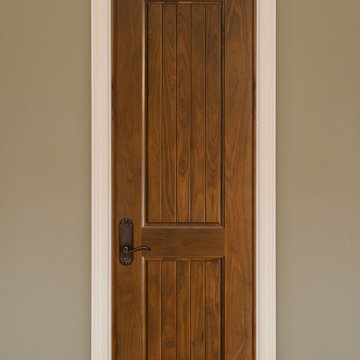
 Glenview Haus – Custom Doors & Wine Cellars
Don't let your interior doors be written off as some functional piece of hardware. Come to Glenview Haus and make your interior doors just as stunning as the rest of your home. Glenview Haus' Traditional Wood Interior Door Collection ensures that every door stands out with all the elegance and style. Our Traditional wooden doors are finely made by expert artisans and designed with all of your needs in mind.
 Sweet Smiling Landscape Design
This project was do in collaboration with my friends at Sweetwater Collaborative. Sweetwater Collaborative is a non-profit organization that work to educate the public about water wise and regenerative landscape practices.
Funded by the City of Santa Barbara as well as several other business and agency Sweetwater Collaborative and I worked to installed this project with the help of volunteers. In a hands-on work shop we explained principles of water wise gardening and demonstrated best practices when installing sustainable landscapes.
When the owner of this property decided to build an ADU ( Auxiliary Dwelling Unit) in their back yard they expanded the roof line of their property. In order to be in compliance with new California building the project required that a portion of the rain water coming onto this property must be stored on the property. That is where we came into help. Directing down spouts into basins, or swales in the soil is one of the most efficient and cost-effective way to capture and store rain water on a piece of land.
Calculations were done to determine the volume of water coming of the roof line in a given rain event from the ADU. The calculations go: square footage of roofline times .62 times 1, for 1” of rain. That total gives you the amount of water in gallons. Then divide the number in gallons by 7.48 find the cubic feet in that number of gallons. Then a basin with that holding capacity was designed into the landscape. Then the plantings were chosen. In this project we went with an 100% California Native Plant palette. We did this to help educate people about all the benefits of growing natives and to show case some of the beautiful plants native to Southern California. Sothern California is how to some of the greatest biodiversity of plants in the world. Native Plants are best adapted to thrive conditions from which they are natively found plus they help provide forage to the native fauna such as birds and insects.
Now the tenants in the ADU can look out and enjoy this colorful garden without the home owners needing to pay a huge water bill.


 Sweet Smiling Landscape Design
This project was do in collaboration with my friends at Sweetwater Collaborative. Sweetwater Collaborative is a non-profit organization that work to educate the public about water wise and regenerative landscape practices.
Funded by the City of Santa Barbara as well as several other business and agency Sweetwater Collaborative and I worked to installed this project with the help of volunteers. In a hands-on work shop we explained principles of water wise gardening and demonstrated best practices when installing sustainable landscapes.
When the owner of this property decided to build an ADU ( Auxiliary Dwelling Unit) in their back yard they expanded the roof line of their property. In order to be in compliance with new California building the project required that a portion of the rain water coming onto this property must be stored on the property. That is where we came into help. Directing down spouts into basins, or swales in the soil is one of the most efficient and cost-effective way to capture and store rain water on a piece of land.
Calculations were done to determine the volume of water coming of the roof line in a given rain event from the ADU. The calculations go: square footage of roofline times .62 times 1, for 1” of rain. That total gives you the amount of water in gallons. Then divide the number in gallons by 7.48 find the cubic feet in that number of gallons. Then a basin with that holding capacity was designed into the landscape. Then the plantings were chosen. In this project we went with an 100% California Native Plant palette. We did this to help educate people about all the benefits of growing natives and to show case some of the beautiful plants native to Southern California. Sothern California is how to some of the greatest biodiversity of plants in the world. Native Plants are best adapted to thrive conditions from which they are natively found plus they help provide forage to the native fauna such as birds and insects.
Now the tenants in the ADU can look out and enjoy this colorful garden without the home owners needing to pay a huge water bill.
 Sweet Smiling Landscape Design
This project was do in collaboration with my friends at Sweetwater Collaborative. Sweetwater Collaborative is a non-profit organization that work to educate the public about water wise and regenerative landscape practices.
Funded by the City of Santa Barbara as well as several other business and agency Sweetwater Collaborative and I worked to installed this project with the help of volunteers. In a hands-on work shop we explained principles of water wise gardening and demonstrated best practices when installing sustainable landscapes.
When the owner of this property decided to build an ADU ( Auxiliary Dwelling Unit) in their back yard they expanded the roof line of their property. In order to be in compliance with new California building the project required that a portion of the rain water coming onto this property must be stored on the property. That is where we came into help. Directing down spouts into basins, or swales in the soil is one of the most efficient and cost-effective way to capture and store rain water on a piece of land.
Calculations were done to determine the volume of water coming of the roof line in a given rain event from the ADU. The calculations go: square footage of roofline times .62 times 1, for 1” of rain. That total gives you the amount of water in gallons. Then divide the number in gallons by 7.48 find the cubic feet in that number of gallons. Then a basin with that holding capacity was designed into the landscape. Then the plantings were chosen. In this project we went with an 100% California Native Plant palette. We did this to help educate people about all the benefits of growing natives and to show case some of the beautiful plants native to Southern California. Sothern California is how to some of the greatest biodiversity of plants in the world. Native Plants are best adapted to thrive conditions from which they are natively found plus they help provide forage to the native fauna such as birds and insects.
Now the tenants in the ADU can look out and enjoy this colorful garden without the home owners needing to pay a huge water bill.
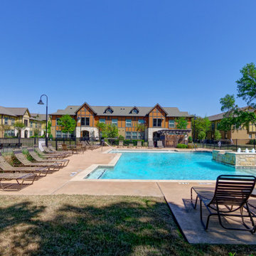
 Dallas Builders Association
Britain Way Apartments, located at 333 Lane St. in Irving, has reborn with a fresh rejuvenated appeal. Built in 1962, the original development structure had been noticeably deteriorating in recent years. It had limited amenities, 17 repetitive, monotonous buildings with dull colors and obsolete mansard roofs in dilapidated condition. There was poor on-site drainage and lighting, no perimeter fencing, and several city code violations were recorded in prior years. The Developer’s mission was to convert this dated project into a high quality, eco-friendly, modern, and affordable housing community for the citizens of Irving.
After the remodel was completed, enhanced features include visually pleasing facades using heavy stone accents and sloping roofs, and lush landscaping distributed throughout the site. Additional improvements include expanded kitchen areas with upgraded interior amenities and energy efficient appliances; second bathrooms added to select two- and three-bedroom units; a brand-new spacious clubhouse and community center was provided; pool and picnic areas and an on-site resident activities coordinator to lead an abundance of community services provided to residents at no extra cost. Strategic partnerships, with community-based organizations, local volunteer groups and non-profits offer lifestyle and learning activities such as arts and crafts and after-school reading and tutoring for children, computer classes, lifestyle enrichment classes, nutrition classes and aquatic activities for children and adults.
Britain Way is the first LEED Gold Certified affordable multifamily community in the city of Irving. LEED certification ensures the property will be healthier and safer for residents in addition to providing lower utility expenses, as well as, conserving energy and water. Obtaining LEED Gold Certification for a 60-year-old project was a herculean effort.
Further enhancing the project’s resident quality of life initiatives, the new, stylish Britain Way is designed per implementing “Crime Prevention Through Environmental Design” (CPTED) requirements. Among several other updates, the property was made safer by adding perimeter fencing and increasing lighting levels throughout the site.
To tour Britain Way or for more information on availability of this apartment community or any other available properties, please visit www.omhousing.com or https://www.britainwayapts.com/
This Home of the Week is presented by the Dallas Builders Association. For information on the Association please visit www.dallasbuilders.com.
 Envision Web
Stuart Wade, Envision Virtual Tours
Envision Virtual Tours and High Resolution Photography is your best choice to find just what you are looking for in the Lake Burton Area . Knowing the areas and resources of Lake Burton is our specialty
Lake Burton is a 2,775 acre man-made lake with 62 miles of shoreline located in the northeastern corner of Georgia in Rabun County. It is the first lake in a five-lake series called the Tallulah River Watershed that follows the original course of the Tallulah River. The series of lakes starts with Lake Burton as the northernmost lake followed by Lake Seed, Lake Rabun, Lake Tallulah Falls and the eastern arm of Lake Tugalo (the western arm is formed by the Chattooga River. The lakes are owned and operated by the Georgia Power Company to generate hydroelectric energy for Georgia's largest city, Atlanta. At one time these lakes were the largest producers of electricity in the state of Georgia. Now, they only provide peak power supply.
The lake was built in a deep valley located along a 10 mile section of the Tallulah River. The Lake Burton Dam was closed on December 22, 1919 and the lake started to fill. The dam is a gravity concrete dam, with a height of 128 feet and a span of 1,100 feet. The spillway is equipped with eight gates 22 feet wide by 6.6 feet high. The total capacity at an elevation of 1,866.6 feet is 108,000 acre-ft, of which 106,000 acre-ft is usable storage. The generating capacity of the dam is 6,120 kilowatts (two units).Lake Burton is the highest Georgia Power lake in Georgia.
Lake Burton gets its named from the town of Burton, which was the second largest town in Rabun County with a population of approximately 200 but now lies below the lake's surface. The town (and the lake) was named after local prominent citizen Jeremiah Burton and was situated along the road from Clayton, Georgia to the Nacoochee Valley. Andrew Jackson Ritchie served as the postmaster for the area for several years. Gold was first discovered in Rabun County where Dicks Creek and the Tallulah River come together and was the reason for the town's founding in the early 1800s.
The Lake Burton Fish Hatchery and Moccasin Creek State Park are located on the western side of the lake. Lake Burton is home to several species of fish, including Spotted Bass, Largemouth Bass, White Bass, Black Crappie, Bluegill, Redear Sunfish, White Catfish, Walleye, Brown Trout, Rainbow Trout, and Yellow Perch.
The residents of Lake Burton are a mix of permanent residents and seasonal vacationers who together make-up the Lake Burton Civic Association, a local organization who goal is to maintain the lake through volunteer clean-ups and other such events. Let a Lake Burton resident and expert show you the way
The Lake Burton Civic Association is an active homeowners association for residents of the Lake Burton area and sponsors many events throughout the year such as:
burton, custom, envision, georgia, lake, mountain, nc, north, photography, web, western, Lake Burton, Lake Rabun, Seed Lake,Virtual Tours.
 Sweet Smiling Landscape Design
This project was do in collaboration with my friends at Sweetwater Collaborative. Sweetwater Collaborative is a non-profit organization that work to educate the public about water wise and regenerative landscape practices.
Funded by the City of Santa Barbara as well as several other business and agency Sweetwater Collaborative and I worked to installed this project with the help of volunteers. In a hands-on work shop we explained principles of water wise gardening and demonstrated best practices when installing sustainable landscapes.
When the owner of this property decided to build an ADU ( Auxiliary Dwelling Unit) in their back yard they expanded the roof line of their property. In order to be in compliance with new California building the project required that a portion of the rain water coming onto this property must be stored on the property. That is where we came into help. Directing down spouts into basins, or swales in the soil is one of the most efficient and cost-effective way to capture and store rain water on a piece of land.
Calculations were done to determine the volume of water coming of the roof line in a given rain event from the ADU. The calculations go: square footage of roofline times .62 times 1, for 1” of rain. That total gives you the amount of water in gallons. Then divide the number in gallons by 7.48 find the cubic feet in that number of gallons. Then a basin with that holding capacity was designed into the landscape. Then the plantings were chosen. In this project we went with an 100% California Native Plant palette. We did this to help educate people about all the benefits of growing natives and to show case some of the beautiful plants native to Southern California. Sothern California is how to some of the greatest biodiversity of plants in the world. Native Plants are best adapted to thrive conditions from which they are natively found plus they help provide forage to the native fauna such as birds and insects.
Now the tenants in the ADU can look out and enjoy this colorful garden without the home owners needing to pay a huge water bill.
 Envision Web
Stuart Wade, Envision Virtual Tours
Envision Virtual Tours and High Resolution Photography is your best choice to find just what you are looking for in the Lake Burton Area . Knowing the areas and resources of Lake Burton is our specialty
Lake Burton is a 2,775 acre man-made lake with 62 miles of shoreline located in the northeastern corner of Georgia in Rabun County. It is the first lake in a five-lake series called the Tallulah River Watershed that follows the original course of the Tallulah River. The series of lakes starts with Lake Burton as the northernmost lake followed by Lake Seed, Lake Rabun, Lake Tallulah Falls and the eastern arm of Lake Tugalo (the western arm is formed by the Chattooga River. The lakes are owned and operated by the Georgia Power Company to generate hydroelectric energy for Georgia's largest city, Atlanta. At one time these lakes were the largest producers of electricity in the state of Georgia. Now, they only provide peak power supply.
The lake was built in a deep valley located along a 10 mile section of the Tallulah River. The Lake Burton Dam was closed on December 22, 1919 and the lake started to fill. The dam is a gravity concrete dam, with a height of 128 feet and a span of 1,100 feet. The spillway is equipped with eight gates 22 feet wide by 6.6 feet high. The total capacity at an elevation of 1,866.6 feet is 108,000 acre-ft, of which 106,000 acre-ft is usable storage. The generating capacity of the dam is 6,120 kilowatts (two units).Lake Burton is the highest Georgia Power lake in Georgia.
Lake Burton gets its named from the town of Burton, which was the second largest town in Rabun County with a population of approximately 200 but now lies below the lake's surface. The town (and the lake) was named after local prominent citizen Jeremiah Burton and was situated along the road from Clayton, Georgia to the Nacoochee Valley. Andrew Jackson Ritchie served as the postmaster for the area for several years. Gold was first discovered in Rabun County where Dicks Creek and the Tallulah River come together and was the reason for the town's founding in the early 1800s.
The Lake Burton Fish Hatchery and Moccasin Creek State Park are located on the western side of the lake. Lake Burton is home to several species of fish, including Spotted Bass, Largemouth Bass, White Bass, Black Crappie, Bluegill, Redear Sunfish, White Catfish, Walleye, Brown Trout, Rainbow Trout, and Yellow Perch.
The residents of Lake Burton are a mix of permanent residents and seasonal vacationers who together make-up the Lake Burton Civic Association, a local organization who goal is to maintain the lake through volunteer clean-ups and other such events. Let a Lake Burton resident and expert show you the way
The Lake Burton Civic Association is an active homeowners association for residents of the Lake Burton area and sponsors many events throughout the year such as:
burton, custom, envision, georgia, lake, mountain, nc, north, photography, web, western, Lake Burton, Lake Rabun, Seed Lake,Virtual Tours.
22