Software
Houzz Logo Print
sabrinatx

Looking for a program to site map our property.

9 years ago

Does anyone know of a program that I could use to site my house, out buildings, and pastures using my survey? Before we start building we would like to have a general layout of our whole property and how to best use the space we have. It's only 5 acres and will have two or three horses, some goats (for ag exemption) and a few chickens.


Thanks

Comments (20)

  • 9 years ago

    That is part of the services that your architect can provide.

  • 9 years ago

    Thank you Sophie but I was looking for a program that I could play around with. I'll keep googling until I find something that works. I've already used grid paper and drawn by hand but would like to find something that would give me precise measurements.

  • PRO
    9 years ago

    Are you wanting a topographical (3D) type of plan, or just a 2D representation?


    You might research the Home Designer products. They have the ability to do both, although 5 acres will be a good bit of work to develop an accurate contour map. Just laying out the boundaries and then positioning structures in 2D is much simpler.

  • 9 years ago

    Does you county already have a GIS system? I can get into ours and get it to give me the layout with dimensions, topographical indicators if I want them, ditto for satellite info, and them just transfer that image into something like Adobe illustrator.

  • 9 years ago

    PPF. Just laying out the boundaries and then positioning structures in 2D is much simpler.

    This is what I am wanting to do. I'm trying to figure out how many pastures I can get on my property for rotational grazing. I need to be able to size each pasture and figure out the distance from house to barn to pastures. As you can see I'm trying to squeeze out every inch of my land and putting it to good use.

    Would sketchup be able to do this?

  • 9 years ago
    last modified: 9 years ago

    5 acres isn't pastures with a plural. It's a single pasture of about 4 acres, with a small barn, and hopefully with a pond. And 2 horses max, with supplemental winter feeding. If you mix goats and horses, that will be supplemental feeding year round. Chickens will require a permanent fenced enclosure, dug into the ground, and roofed with chicken wire. Otherwise, you will end up chickenless when the raccoons or foxes eat them.

  • 9 years ago

    Holly would adobe illustrator be able to give me the measurements and distance info I'm looking for? I've taken a picture of my property via google maps and put it into ms paint. Then I drew out the house, barn, pastures, ect. The only problem is I don't know if what I've drawn is feasible to work with when it comes time to fence in the pastures.

    I really hope I'm making myself clear.

  • 9 years ago

    Not if you break up those 4 acres into small pastures for rotational grazing. No pond on site but I do have a what we call a resaca (irrigation canal for watering crops).

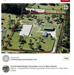
    It is recommended one horse per acre but will only have two or possibly 3. In the picture I posted each pasture would get one week use and then 4 to 5 weeks rest to let the grass recover.

    I wish my property was a perfect square like this picture. I would just copy this layout but atlas it's not. LOL

    Thank you for trying to help me. I really appreciate it!

  • 9 years ago

    Do you own the water rights to the irrigation ditch? If not, then you can not use it for any needs. You will need a bigger well, especially if you are in the more arid regions of TX. That also limits the natural forage available for grazing, and increases the needs for supplemental outsourced nutrition for the livestock. 5 acres simply is not enough to fully support the pasture needs of that many animals. Yes, I did 4H growing up and lived through a childhood with all manner of farming happening.

  • 9 years ago

    No, although the GIS system has both distance and area measurement features. I'd just use that. This is the link to the version for my county:
    https://gis.miottawa.org/ottawa/geocortex/propertymapping/

    You can click on any lot, and use the tools to draw polygons, freehand areas, measure distance and area, etc. It will also mark easements.etc.

  • 9 years ago

    I would do what the others said. I would go to the county GIS site. Use their tools to get all your distances and plot it our on graph paper. It really is much faster for playing around with layouts. Use tracing paper for various set ups. Once you get one or two you like, then bring in the software.

  • 9 years ago

    Doc5md What I'm trying to figure out is what software would I use. I've already tried grid paper and well lets say it didn't come out to well. I would do better with a program and gives me the exact measurement I want without all of the thinking involved! LOL

    Sophie you make a lot of assumptions but let me clear it up for you. I want to do rotational grazing pastures to feed my horses and yes I do plan to give them grain and hay. I never said I was going to try to fully support them in this manner. I mean I know my land is only a pitiful 5 acres but my goal is to manage it as best as I can and not turn it into a dry lot. Yes I have rights to the water irrigation in the form of 200.00 a year for unlimited use. Oh and I also have city water to boot! Seriously I'm not going into this blind. I'm just looking for a program to help me layout my property for best use of space.

    Holy I'll look into the GIS and maybe that's all I need. Thanks

    Thank you everyone for replying and offering help.

  • 9 years ago

    are you certain you can get ag exemption with only five acres? Are you in Cameron county? Here in Waller county we need more than five acres (which is what I have). You can get away with fewer acres if you are doing bees. Let me know if you want more info re my chicken house/pen.

  • 9 years ago

    Having used the software.... I'm telling that honestly it is much faster and quicker to use grid paper. Just because you are using software, doesn't mean it will come out better.
    I have chief architect... but playing with terrain layout is very tricky and time consuming... and frustrating.

    The GIS and graph paper may be all you need.. Once you see what the GIS is capable of telling you :) Its really fun!

  • 9 years ago

    New-beginning, the land previously had ag exempt. County actually removes the ag exempt when we purchased the land and I have 5 years to get it place back on the property in our name. Yes I am located in Cameron County. Kinda freaked me out there a bit until I looked at my profile. LOL

    I guess I'll go back to the damn paper route.

    Thanks everyone for y'alls input.

  • 9 years ago

    I made a map of our property- an irregular 7-1/2 acres- using Sketch-Up and working off our survey. I like drawing on the computer, as it's easy to make changes, save each one with a different name, and then be able to quickly compare them. As I've developed our place, I drew in the buildings, water and electric lines, and septic system. Years from now some future owner will be glad I marked all of that stuff out!

  • 9 years ago

    Like Holly, I began with our county GIS maps and aerial photographs, Google Earth, and imported them into Illustrator to give the county proposed placement of the house, driveway access, distances to property lines and resources (we're on a forestry deferral), and for my own landscaping design and barn/corral fence placement. (Ask me how fun this all is on a heavily forested property – thank goodness for Google Earth's historical views) However, Illustrator is professional design software with a very steep learning curve unless you are already experienced using it (I've used it for over 25 years in my design/illustration business). It is also expensive, so you probably wouldn't want to buy it just for this single purpose. You might do better using Photoshop, which is a bit more intuitive, although the drawing tools and layers have their own difficulties.

    The GIS maps included measurements for property lines and topographical markings (we're on a hillside, and this allowed me to show that our driveway met county restrictions). I also used their on-line measuring tools to give distances to property lines, since physically measuring would have meant rappelling into the ravine that marks one property edge.

    As is typical in my life, I presented the building department with a thorough, accurate rendering of our four acres with existing structures, driveway and road access, septic system, well, power lines, etc., etc., and they laughed and said they normally received chicken scratch drawings with no pretense of scale.

  • 9 years ago

    Our GIS system allows you to overlay everything: elevations, easements, flood plains, etc. I'd like to think that perhaps you could then get that to a scale and trace it onto graph paper if you wanted to pencil in more detail.

    Good luck to you on your project - I have some acreage and have been threatening hubby to get a horse and a mini donkey when we move in!

  • 9 years ago
    last modified: 9 years ago

    A blank sheet of 11x17 paper, with suitable 2d scale cutouts of physical structures before even using a grid or software which I initially used Punch Home Design. It was easy to move scale cutouts using paper glue to hold them in place.

    Five acres is relatively easier to map manually in a short time. Mapping our six acres was somewhat easier since it is an almost perfect rectangle, over a period of few days with a 300' and a 100' tape measure. I marked several reference points, measured distances, directions and orientation, calculated angles between reference points, then hired a professional surveyor to validate them who then also provided a formal site plan which I used for the building permit application. With wetlands on the property, there was a need to perfectly size up and precisely map the build envelop, a storm water pond and other markings.