Software
Houzz Logo Print
toronado3800

If you leave a field alone...

If anyone in any of the houses I have lived at in the St Louis area doesn't mow the honeysuckle, grape vine, bradfords then maples and other trees are going to take over.
My assumption is anyplace that is now mowed except for a few rocky hills and the floodplain will become woodland.
Do you think that assumption is correct?
Hiw is it where u all live?

Comments (21)

  • 3 years ago

    I saw it happen growing up. A cultivated field became a woods in about 20 years.

    tj

  • 3 years ago

    As long as there is some soil, I believe it is safe to assume that give sufficient time any area will become a woodland, assuming there is sufficient yearly moisture.

  • 3 years ago

    Most of the Farm fields where I live were once wood lands and some of the poorer ground that wasn't plowed for a while has returned to trees.

    Although there is natural 'Prairie' West of MN that has always been grass lands, FWICT.

  • 3 years ago

    Succession for most the US has always been forests. The only reason there are prairies is/was burning (either naturally or man-made)

  • 3 years ago

    I believe the rain shadow of the Rockies gave rise to the prairie. Fire is sometimes used to maintain them.

  • 3 years ago

    Even the Dust bowl era 100 mi. wide, great plains states tree planting project of FDR didn't cause the land to become a forest. 3 billion trees planted from Dakotas to Texas.

    There are vast areas out there that trees just don't grow or don't grow very well at all.

    There's the semi-arid climate, the alkaline soils and the fact that the incessant winds tend to decimate young trees.

    There are a lot of places they're working on it, but no way does that land do what it's does out east and naturally grow back to forest.

    Must be why they call them 'The Great Plains'. ;-)


    https://nebraskapublicmedia.org/en/news/news-articles/fdrs-great-wall-of-trees-the-prairie-states-forestry-project/


  • 3 years ago

    Yeah, uncultivated land can look like 'The Great Plains' or the 'Amazon Rainforest'. If you neglect your garden, it will revert to one or the other depending on where you are ...

  • 3 years ago

    Where is the line between the forested east and the plains? Tulsa/Wichita/Omaha?

  • 3 years ago
    last modified: 3 years ago
  • 3 years ago

    Another;

    From what I've seen this map is pretty accurate of the Great Plains.

    https://usa.usembassy.de/etexts/outgeogr/map10.htm

  • 3 years ago

    Makes me wonder if our individual horticultural endeavors will have some enduring micro-local impact or not ...

  • 3 years ago

    I'm fairly confident that my entire backyard would be overrun by Eastern cottonwood, box elder, American elm, eastern red cedar and smooth sumac in under 5 years. I already have some type of scrub willow creeping under the ground and pushing up shoots all over the very back near the pond.


    I see what Bill sees. MN would become mostly forest again. With no human intervention, a prolonged, widespread drought is the only thing that would slow that down.

  • 3 years ago

    An interesting thing about Minnesota is; A chunk of the Southwest part of the state and along the far western parts of the state, you begin to see the 'Prairie'.


    The only trees you see are plantings and, in some areas, the planted ones are around homesteads, installed as windbreaks and are maintained as such, with miles of open areas all around.


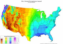
    I've posted this map before. It shows how the further west you go in the US, the rainfall decreases.


    I'm in an area that says I get 28" annually, HA!


    Even if I add a few inches to what I've already totaled up for this year; 4-5" worth of rain with the heavy snow melt, plus the 2-3" of rain we've received so far this season. That's 8" and if we still get a few inches this Fall, after the growing season, it amounts to 11-12" annually.


    I admit, this has been drier than normal this year (but I won't say abnormally drier bc we've had this type of weather several times in the past 30 years), but even if you add another 4-6" rain during the summer which would be a lot closer to 'a good season' for us, that's still far from the 28" average alluded to on the map.


    You can decide for yourself. But next time the weatherman comes on the TV and amplifies the fact that it's Hot and Dry in S. Cal., Nevada, AZ, and other places out that way, you have to ask yourself, could that possibly be because it's the area Historically called the 'Desert Soutwest'?


    You guys out east need to get out and about more haha. ;-)

  • 3 years ago

    Just for informational sake:

    This is not designated to be a 'Safe site', so beware of that.

    Maps of soil type:

    http://www.bonap.org/2008_Soil/SoilTypesRelatedMaps.html

  • 3 years ago

    Look up 100th meridian (100º west of Greenwich); that's what I had learned was the approximate dividing line of moist eastern lands and arid western lands in North America.

  • 3 years ago
    last modified: 3 years ago

    Wow, that's an eye opener VV!

    Makes me wonder if that's why it's been so dry here for the last 3 seasons. :-\

  • 3 years ago
    last modified: 3 years ago

    The neighbor's fallow field adjacent to my lot is solid grass, or mixture of grass, goldenrod (6 ft tall), a few asters, multifloral rose and some parts smothered w/native clematis vine. I don't think any trees are getting in there any time soon, except maybe squirrel-planted black walnuts (and my guerrilla-planted trees).

  • 3 years ago
    last modified: 3 years ago

    My 9.6-acre field that was on my place when I bought it,

    `45 years ago, had trees planted along the west side by the road. Most of those died during some very dry years.

    Where the high sandy ground occurs, there are scattered jack pines 6-12 feet tall. I replanted the trees along the road and they're getting fairly good sized today.

    I kept about half the field cultivated with wildlife food plots but where there is lower dips in the field, that have more clayish loam and the moisture is more consistent, those have gone completely back to woods and willows, poplars, pines etc.

    The field is approx. 4-5 acres today.

  • 3 years ago

    Wow!! The maps of the 100th median are amazing!

    debra

  • 3 years ago

    Here’s an article on the northern mixed/southern broadleaf tension zone, specific to MN & WI and factors including temps, precip, soil type, and fire:https://www.fs.usda.gov/nrs/pubs/jrnl/2022/nrs_2022_nowacki_001.pdf