
3D Ariel Mapping
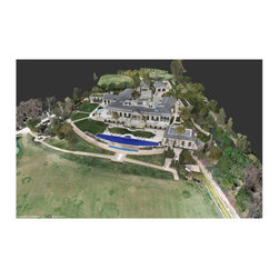
Developed a 3D Aerial Map for this $65 million dollar estate.
www.120montecito.com/aerial-3d-map/
Our drones can produce sophisticated 2D maps and 3D digital elevation models that enable you to fill in imaging gaps left by satellite mapping with up-to-date data. Orthomosaic maps are created with a large number of overlapping photos covering a defined area. After capturing precise aerial imagery, we then use software to knit the photos into georectified orthomosaics.
You can harness the meta-information found within the geo-referenced orthomosaics to compute point clouds, volumetrics, NDVI, 3D digital surface and terrain models.
Normalized Difference Vegetation Index (NDVI) images are captured with drone cameras that can see in both the visual and the near-infrared spectrum. The images can provide critical data on plant health by measuring the current amount of chlorophyll in the vegetation.
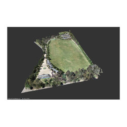
We will provide you with an advanced 3D model of your land. You can fully interact with the model and use it to perform calculations, including measuring distance, area, and volume. These tools are ideal for getting measurements of construction sites, calculating areas of fields, and understanding where where equipment is located.
Our drones can produce sophisticated 2D maps and 3D digital elevation models that enable you to fill in imaging gaps left by satellite mapping with up-to-date data. Orthomosaic maps are created with a large number of overlapping photos covering a defined area. After capturing precise aerial imagery, we then use software to knit the photos into georectified orthomosaics.
You can harness the meta-information found within the geo-referenced orthomosaics to compute point clouds, volumetrics, NDVI, 3D digital surface and terrain models.
Normalized Difference Vegetation Index (NDVI) images are captured with drone cameras that can see in both the visual and the near-infrared spectrum. The images can provide critical data on plant health by measuring the current amount of chlorophyll in the vegetation.
We will provide you with an advanced 3D model of your land. You can fully interact with the model and use it to perform calculations, including measuring distance, area, and volume. These tools are ideal for getting measurements of construction sites, calculating areas of fields, and understanding where where equipment is located.
www.120montecito.com/aerial-3d-map/
Our drones can produce sophisticated 2D maps and 3D digital elevation models that enable you to fill in imaging gaps left by satellite mapping with up-to-date data. Orthomosaic maps are created with a large number of overlapping photos covering a defined area. After capturing precise aerial imagery, we then use software to knit the photos into georectified orthomosaics.
You can harness the meta-information found within the geo-referenced orthomosaics to compute point clouds, volumetrics, NDVI, 3D digital surface and terrain models.
Normalized Difference Vegetation Index (NDVI) images are captured with drone cameras that can see in both the visual and the near-infrared spectrum. The images can provide critical data on plant health by measuring the current amount of chlorophyll in the vegetation.
We will provide you with an advanced 3D model of your land. You can fully interact with the model and use it to perform calculations, including measuring distance, area, and volume. These tools are ideal for getting measurements of construction sites, calculating areas of fields, and understanding where where equipment is located.
Our drones can produce sophisticated 2D maps and 3D digital elevation models that enable you to fill in imaging gaps left by satellite mapping with up-to-date data. Orthomosaic maps are created with a large number of overlapping photos covering a defined area. After capturing precise aerial imagery, we then use software to knit the photos into georectified orthomosaics.
You can harness the meta-information found within the geo-referenced orthomosaics to compute point clouds, volumetrics, NDVI, 3D digital surface and terrain models.
Normalized Difference Vegetation Index (NDVI) images are captured with drone cameras that can see in both the visual and the near-infrared spectrum. The images can provide critical data on plant health by measuring the current amount of chlorophyll in the vegetation.
We will provide you with an advanced 3D model of your land. You can fully interact with the model and use it to perform calculations, including measuring distance, area, and volume. These tools are ideal for getting measurements of construction sites, calculating areas of fields, and understanding where where equipment is located.
Project Year: 2019