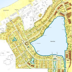


36. Beachwalk Neotraditional Community Developments Planning and ARG Review
The main objective in the planning and design of Beachwalk was to create a strong link between the community and the Lake Michigan Shoreline. This link not only had to occur between the site and the Lake but also needed to extended into, and be reinforced within the site itself
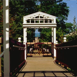
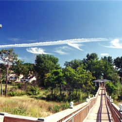
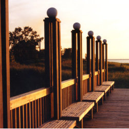
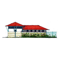
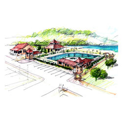
The connection with the Lake was established by constructing a handicapped accessible esplanade punctuated with a series of pavilions. Funded by the Developer and subsequently donated to the City for public access this esplanade traverses across an 800’ long stretch of public beach access. The pavilions provide resting areas and break up the 800’ long esplanade that is softly raised above grade to permit the sand dunes and grasses to undulate underneath. The terminus of this esplanade is the “Land Pier” which shifts its focus to the Michigan City Lighthouse beyond.
Connectivity within the development itself was achieved by using existing, and newly created, water features on the site as focal points for a series of newly planned neighborhoods. In addition to Lake Kai, other water features were created to accommodate surface runoff and these again were organized to create focal points for streets and pedestrian paths. The result of these water features for the community was to reinforce the idea of being on the water’s edge, and as such, formed a cognitive connection to Lake Michigan
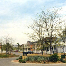
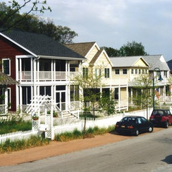
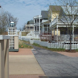
The Neighborhoods created within Beachwalk also reinforce this connectivity. Each neighborhood has a distinct identity that was shaped and formed by a combination of steep sand dune topographic features, existing fragile ecosystems, and adjacent historic land use patterns. Through a network of narrow streets, alleys, pedestrian walks, and public spaces, all the neighborhoods were connected to one another. The main streets all focused on some form of water feature, again reinforcing the idea of being near the water’s edge. Furthermore, the entire community was interwoven into the existing urban fabric through the use of multiple pedestrian and vehicular entries. The planning patterns reflect the existing “bowl” form of the sand mining operation, the steeply surrounding dunes, inland lakes, and the community’s connectivity to Lake Michigan.
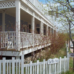
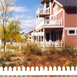
In addition to planning of streets and neighborhoods, a common vision for the community was developed. Historical precedents from adjacent communities were blended with current market and planning strategies to develop not only architectural, but also ecological guidelines that defined a set of common goals and objectives for the development and growth of the community. These goals included the creation and maintenance of a pedestrian oriented community that not only fostered social interaction through the creation of outdoor rooms and spaces but also extended an invitation to the surrounding areas to participate in its social-economic development.
To accommodate growth and change, the ARCHITECTURAL AND ECOLOGICAL CODE was created to promote simple, durable, and cost effective buildings. Simplicity in design, creation of outdoor public and private spaces, and the use of renewable materials were all strongly encourage so as to create a community that promoted an efficient use and sharing of the natural resources.
The planning of Beachwalk reflects an economical and socially responsible land use and development. An unwanted parcel of land that was used as a sand mine was visually connected with the Lake Michigan Shoreline, thereby creating a desirable place to live. Neo-traditional planning design strategies enabled intense development of strategic portions of the property; thereby preserving the sand dunes as open space.
The connection with the Lake was established by constructing a handicapped accessible esplanade punctuated with a series of pavilions. Funded by the Developer and subsequently donated to the City for public access this esplanade traverses across an 800’ long stretch of public beach access. The pavilions provide resting areas and break up the 800’ long esplanade that is softly raised above grade to permit the sand dunes and grasses to undulate underneath. The terminus of this esplanade is the “Land Pier” which shifts its focus to the Michigan City Lighthouse beyond.
Connectivity within the development itself was achieved by using existing, and newly created, water features on the site as focal points for a series of newly planned neighborhoods. In addition to Lake Kai, other water features were created to accommodate surface runoff and these again were organized to create focal points for streets and pedestrian paths. The result of these water features for the community was to reinforce the idea of being on the water’s edge, and as such, formed a cognitive connection to Lake Michigan
The Neighborhoods created within Beachwalk also reinforce this connectivity. Each neighborhood has a distinct identity that was shaped and formed by a combination of steep sand dune topographic features, existing fragile ecosystems, and adjacent historic land use patterns. Through a network of narrow streets, alleys, pedestrian walks, and public spaces, all the neighborhoods were connected to one another. The main streets all focused on some form of water feature, again reinforcing the idea of being near the water’s edge. Furthermore, the entire community was interwoven into the existing urban fabric through the use of multiple pedestrian and vehicular entries. The planning patterns reflect the existing “bowl” form of the sand mining operation, the steeply surrounding dunes, inland lakes, and the community’s connectivity to Lake Michigan.
In addition to planning of streets and neighborhoods, a common vision for the community was developed. Historical precedents from adjacent communities were blended with current market and planning strategies to develop not only architectural, but also ecological guidelines that defined a set of common goals and objectives for the development and growth of the community. These goals included the creation and maintenance of a pedestrian oriented community that not only fostered social interaction through the creation of outdoor rooms and spaces but also extended an invitation to the surrounding areas to participate in its social-economic development.
To accommodate growth and change, the ARCHITECTURAL AND ECOLOGICAL CODE was created to promote simple, durable, and cost effective buildings. Simplicity in design, creation of outdoor public and private spaces, and the use of renewable materials were all strongly encourage so as to create a community that promoted an efficient use and sharing of the natural resources.
The planning of Beachwalk reflects an economical and socially responsible land use and development. An unwanted parcel of land that was used as a sand mine was visually connected with the Lake Michigan Shoreline, thereby creating a desirable place to live. Neo-traditional planning design strategies enabled intense development of strategic portions of the property; thereby preserving the sand dunes as open space.
Project Year: Pre-2005
Country: United States
Zip Code: 46360