


- Product Description
- Product Specifications
- Shipping and Returns
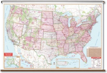
Oversized reference wall maps complete with clearly identified political boundaries comes in the United States edition. This includes thousands of cities, state highways, interstate highways with exit numbers, time zones, waterways, mountain ranges, forests, longitude / latitude lines, plus insets of Puerto Rico, Hawaii and Alaska. All classroom wall maps are made from heavy duty paper and are laminated with a washable surface, and mounted on pull-down spring rollers for convenient classroom storage. These maps are a great way to further students' comprehensive view of the world. The United States Wall Map is perfect for school or home, and comes on your choice of rails, roller or roller with backboard. Features: -Includes roller with backboard -Laminated -Markable with a dry erase or water soluble marker -Detailed labeling of bodies of water and land mass -Detailed legend and color coding -Includes thousands of cities, state highways, interstate highways, time zones, waterways and more -Inset maps of Puerto Rico, Hawaii and Alaska -Perfect for any wall -54" x 77" About the manufacturer: Universal Map presents the world to students in a way that is as visually appealing as it is easy to understand. The extensive line of classroom resources includes coordinating wall maps, rolled maps, deskpad maps, binder maps, outline testing maps and more. The combination of quality and selection is right on target for teachers, schools and home use. Maps give students the visual representation necessary for application of concepts like history, languages and geography. Universal Map prides itself in providing the best educational tools for your child.
Large Scale Wall Map - United States
Oversized reference wall maps complete with clearly identified political boundaries comes in the United States edition. This includes thousands of cities, state highways, interstate highways with exit numbers, time zones, waterways, mountain ranges, forests, longitude / latitude lines, plus insets of Puerto Rico, Hawaii and Alaska. All classroom wall maps are made from heavy duty paper and are laminated with a washable surface, and mounted on pull-down spring rollers for convenient classroom storage. These maps are a great way to further students' comprehensive view of the world. The United States Wall Map is perfect for school or home, and comes on your choice of rails, roller or roller with backboard. Features: -Includes roller with backboard -Laminated -Markable with a dry erase or water soluble marker -Detailed labeling of bodies of water and land mass -Detailed legend and color coding -Includes thousands of cities, state highways, interstate highways, time zones, waterways and more -Inset maps of Puerto Rico, Hawaii and Alaska -Perfect for any wall -54" x 77" About the manufacturer: Universal Map presents the world to students in a way that is as visually appealing as it is easy to understand. The extensive line of classroom resources includes coordinating wall maps, rolled maps, deskpad maps, binder maps, outline testing maps and more. The combination of quality and selection is right on target for teachers, schools and home use. Maps give students the visual representation necessary for application of concepts like history, languages and geography. Universal Map prides itself in providing the best educational tools for your child.
- Product Description
- Product Specifications
- Shipping and Returns
Oversized reference wall maps complete with clearly identified political boundaries comes in the United States edition. This includes thousands of cities, state highways, interstate highways with exit numbers, time zones, waterways, mountain ranges, forests, longitude / latitude lines, plus insets of Puerto Rico, Hawaii and Alaska. All classroom wall maps are made from heavy duty paper and are laminated with a washable surface, and mounted on pull-down spring rollers for convenient classroom storage. These maps are a great way to further students' comprehensive view of the world. The United States Wall Map is perfect for school or home, and comes on your choice of rails, roller or roller with backboard. Features: -Includes roller with backboard -Laminated -Markable with a dry erase or water soluble marker -Detailed labeling of bodies of water and land mass -Detailed legend and color coding -Includes thousands of cities, state highways, interstate highways, time zones, waterways and more -Inset maps of Puerto Rico, Hawaii and Alaska -Perfect for any wall -54" x 77" About the manufacturer: Universal Map presents the world to students in a way that is as visually appealing as it is easy to understand. The extensive line of classroom resources includes coordinating wall maps, rolled maps, deskpad maps, binder maps, outline testing maps and more. The combination of quality and selection is right on target for teachers, schools and home use. Maps give students the visual representation necessary for application of concepts like history, languages and geography. Universal Map prides itself in providing the best educational tools for your child.


At Houzz we want you to shop for Large Scale Wall Map - United States with confidence. You can read real customer reviews for this or any other product and even ask questions and get answers from us or straight from the brand. When you buy Large Scale Wall Map - United States or any product product online from us, you become part of the Houzz family and can expect exceptional customer service every step of the way. If you have questions about or any other product for sale, our customer service team is eager to help.
Browse over 25 million home design photos on Houzz