


Item 1 of 5


Item 1 of 5
- Product Description
- Product Specifications
- Shipping and Returns
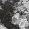
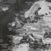
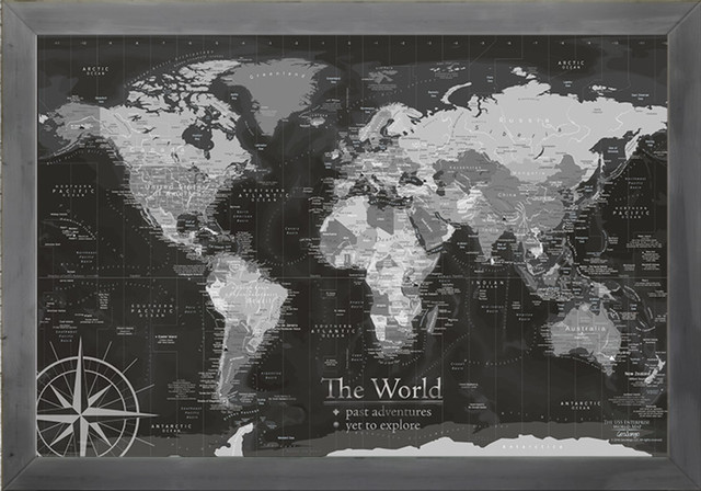
- The USS Enterprise World Map is an modern and detailed map.
- The dark slate design is beautiful and bold.
- Made in the USA by a professional Geographer and Environmental Scientist.
- Great for homeschooling and teaching – this map includes extra details that encourage self-discovery.
- Great for homeschooling and teaching – this map includes extra details that encourage self-discovery.
This map features:
- ✪ True ocean elevation illustrations
- ✪ Geographic and historic commentary
- ✪ Wonders of the World and highlights over 100 fascinating places on Earth
- ✪ Exceptional National Parks around the World
- ▲Tallest Peaks on every continent (special annotation)
- ✪ Our ultra-fabulous and accurate terrain and ocean floor elevation modeling.
- Ocean Currents and Trade Winds
- Ocean, Seas, Gulfs, Straits, Basins, Ridges
- Countries
- Territories
- USA states
- Islands and archipelagos
- Detailed cities throughout the USA, Europe, Australia, India, and more.
- Major lakes
- We modeled the Major Rivers of the World using accurate GIS data and created an striking design - unique to our maps.
About the Cartographer:
This map is made by a professional geographer that is passionate about cartography and has the educational background to make this map more special than any map you've ever owned.The USS Enterprise World Map Black and White, 40"x28", Modern Black Frame
By GeoJango
1 Review
$287
Only 3 Left - Order soon!
Free Shipping
Est. Delivery: May. 16 - May. 23 (to )
Qty: 1
- The USS Enterprise World Map is an modern and detailed map.
- The dark slate design is beautiful and bold.
- Made in the USA by a professional Geographer and Environmental Scientist.
- Great for homeschooling and teaching – this map includes extra details that encourage self-discovery.
- Great for homeschooling and teaching – this map includes extra details that encourage self-discovery.
This map features:
- ✪ True ocean elevation illustrations
- ✪ Geographic and historic commentary
- ✪ Wonders of the World and highlights over 100 fascinating places on Earth
- ✪ Exceptional National Parks around the World
- ▲Tallest Peaks on every continent (special annotation)
- ✪ Our ultra-fabulous and accurate terrain and ocean floor elevation modeling.
- Ocean Currents and Trade Winds
- Ocean, Seas, Gulfs, Straits, Basins, Ridges
- Countries
- Territories
- USA states
- Islands and archipelagos
- Detailed cities throughout the USA, Europe, Australia, India, and more.
- Major lakes
- We modeled the Major Rivers of the World using accurate GIS data and created an striking design - unique to our maps.
About the Cartographer:
This map is made by a professional geographer that is passionate about cartography and has the educational background to make this map more special than any map you've ever owned.- Product ID
- 73465932
- Manufactured By
- GeoJango
- Sold By
- GeoJango Maps
- Size/Weight
- W 40" / D 2" / H 28" / 7 lb.
- Color
- Modern Black Frame
- Materials
- Canvas Map with Black Wood Frame, Made in USA with top quality materials
- Assembly Required
- No
- Category
- Prints And Posters
- Style
- Contemporary
Sold by GeoJango Maps- Free shipping!
Ready to ship to the contiguous U.S. in 2-5 days
This product does not ship to Canada
Note: Free shipping is not available to AK, HI, PR or Canada. Some exclusions apply.
Houzz offers a 30-day standard return policy for most items. We also accept returns on damaged large or oversized items that ship via freight, as long as you report the damage within 5 days of delivery. View our full Return Policy.
- Product Description
- Product Specifications
- Shipping and Returns
- The USS Enterprise World Map is an modern and detailed map.
- The dark slate design is beautiful and bold.
- Made in the USA by a professional Geographer and Environmental Scientist.
- Great for homeschooling and teaching – this map includes extra details that encourage self-discovery.
- Great for homeschooling and teaching – this map includes extra details that encourage self-discovery.
This map features:
- ✪ True ocean elevation illustrations
- ✪ Geographic and historic commentary
- ✪ Wonders of the World and highlights over 100 fascinating places on Earth
- ✪ Exceptional National Parks around the World
- ▲Tallest Peaks on every continent (special annotation)
- ✪ Our ultra-fabulous and accurate terrain and ocean floor elevation modeling.
- Ocean Currents and Trade Winds
- Ocean, Seas, Gulfs, Straits, Basins, Ridges
- Countries
- Territories
- USA states
- Islands and archipelagos
- Detailed cities throughout the USA, Europe, Australia, India, and more.
- Major lakes
- We modeled the Major Rivers of the World using accurate GIS data and created an striking design - unique to our maps.
About the Cartographer:
This map is made by a professional geographer that is passionate about cartography and has the educational background to make this map more special than any map you've ever owned.

At Houzz we want you to shop for GeoJango The USS Enterprise World Map Black and White, 40"x28", Modern Black Frame with confidence. You can read real customer reviews for this or any other product and even ask questions and get answers from us or straight from the brand. When you buy GeoJango The USS Enterprise World Map Black and White, 40"x28", Modern Black Frame or any product product online from us, you become part of the Houzz family and can expect exceptional customer service every step of the way. If you have questions about GeoJango or any other product for sale, our customer service team is eager to help.